 Filter: Categories of Wisconsin Historical Images
Filter: State of Virginia
Filter: Subject of military art and science
Filter: Categories of Wisconsin Historical Images
Filter: State of Virginia
Filter: Subject of military art and science

| Date: | 1865 |
|---|---|
| Description: | The map of the battlefield shows entrenchments, villages, roads, the "South Side Rail Road" drainage, vegetation, relief by hachures, houses, and names of ... |

| Date: | 1862 |
|---|---|
| Description: | This map consists of four separate panels. The first illustrates the battlefield at Cedar Mountain on Aug. 9, 1862, where the 3rd Wisconsin Infantry fought... |

| Date: | 1863 |
|---|---|
| Description: | Quarter plate ferrotype/tintype of Lieutenant Albert Lamson, taken at Falmouth, Virginia. Lamson is posed, in military uniform, seated and holding a sword ... |

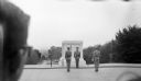
| Date: | 1950 |
|---|---|
| Description: | View from lawn of the Tomb of Unknown Soldier and the Arlington Memorial Amphitheater from the base of the stairs leading to the monument. Groups of men an... |

| Date: | 1950 |
|---|---|
| Description: | View of the changing of the guard at the Tomb of the Unknown Soldier in Arlington Cemetery. |

| Date: | 1950 |
|---|---|
| Description: | View of the inscription on the Tomb of the Unknown Soldier in Arlington Cemetery. The inscription reads: "Here rests in honored glory an American Soldier, ... |
| Date: | 1950 |
|---|---|
| Description: | Changing of the guard at the Tomb of the Unknown soldier. The back of a man's head is in the foreground on the left. |

| Date: | 08 31 1779 |
|---|---|
| Description: | A handwritten "list of different inhabitants that consented to furnish the troops belonging to the state of Virginia." |

| Date: | 1862 |
|---|---|
| Description: | This map shows the plan of the siege of Yorktown and the Battle of Williamsburg. The map also shows fortifications, towns, roads, houses, names of resident... |

| Date: | 1865 |
|---|---|
| Description: | This map shows U.S. cavalry positions in yellow, Confederate infantry positions in blue, and Confederate cavalry positions in red. The map also shows roads... |

| Date: | 1865 |
|---|---|
| Description: | This map shows Union and Confederate lines on May 5th, 6th, and 7th, 1864. The lower left corner includes a key of symbols for batteries, turnpikes, plank ... |

| Date: | 1762 |
|---|---|
| Description: | Map of Virginia and parts of Maryland. It shows borders, boundary lines, Native American tribes and land, towns, forts, roads, mountains, waterfalls, bays,... |

| Date: | 1781 |
|---|---|
| Description: | Map of the southern portion of the Chesapeake Bay and surrounding lands. It shows counties, a few cities and towns, forts, roads, islands, topographical fe... |
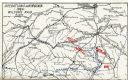
| Date: | 1909 |
|---|---|
| Description: | Map showing operations in Virginia during Wilson's Raid. |
If you didn't find the material you searched for, our Library Reference Staff can help.
Call our reference desk at 608-264-6535 or email us at: