Filter: Categories of Wisconsin Historical Images
Filter: State of Virginia
Filter: Subject of shorelines
Filter: Categories of Wisconsin Historical Images
Filter: State of Virginia
Filter: Subject of shorelines

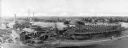
| Date: | |
|---|---|
| Description: | An aerial view of the port and a section of the city showing a large boat, a railway depot, a park plaza and a grid of city streets with large buildings. |

| Date: | 1781 |
|---|---|
| Description: | Map of the southern portion of the Chesapeake Bay and surrounding lands. It shows counties, a few cities and towns, forts, roads, islands, topographical fe... |
If you didn't find the material you searched for, our Library Reference Staff can help.
Call our reference desk at 608-264-6535 or email us at: