 Filter: Categories of Wisconsin Historical Images
Filter: State of Virginia
Filter: Subject of transportation
Filter: Subject of water
Filter: Categories of Wisconsin Historical Images
Filter: State of Virginia
Filter: Subject of transportation
Filter: Subject of water

| Date: | 02 21 1874 |
|---|---|
| Description: | African American boatmen run a rapids in a small river boat. |

| Date: | 06 1862 |
|---|---|
| Description: | The 7th Wisconsin Volunteer Infantry Regiment camp outside of Fredericksburg on the east side of the Rappahannock. Fredericksburg and a pontoon bridge lea... |

| Date: | |
|---|---|
| Description: | An aerial view of the port and a section of the city showing a large boat, a railway depot, a park plaza and a grid of city streets with large buildings. |
| Date: | |
|---|---|
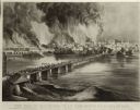
| Description: | Currier & Ives lithograph of the fall of Richmond, April 2, 1865. |
| Date: | |
|---|---|
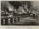
| Description: | "The Evacuation of Richmond Virginia. By the Government of the Southern Confederacy on the Night of April 2nd 1865." Before evacuating, the Confederates se... |

| Date: | |
|---|---|
| Description: | William Howard Taft (S9/15/1857 – 3/8/1930), the 27th President of the United States (3/4/1909 – 3/4/1913), wearing a top hat and sitting in a boat with a ... |

| Date: | |
|---|---|
| Description: | Elevated view of a road and river winding through a mountainous landscape, seen from Waterlick White Hotel. Caption reads: "View from Hotel, Waterlick whit... |

| Date: | |
|---|---|
| Description: | View down hill toward the York River with small homes on its banks. Long piers stretch into the river. |

| Date: | |
|---|---|
| Description: | View across water toward a stone bridge with two arches, built in the late nineteenth century, in the wooded setting of Bull Run Battlefield. |
| Date: | 1957 |
|---|---|
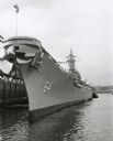
| Description: | U.S.S. Wisconsin docked on the Hudson River at Norfolk, during decommissioning ceremonies. |

| Date: | 11 1957 |
|---|---|
| Description: | Uniformed sailors gathered on the deck of the U.S.S. Wisconsin during decommissioning ceremonies. |

| Date: | 1864 |
|---|---|
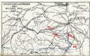
| Description: | This map of the area of the First Battle of Bull Run shows military positions and troop movements as well as the names of landowners, vegetation and land u... |

| Date: | 1864 |
|---|---|
| Description: | This map created during the Civil War indicates Confederate fortifications, houses, names of residents, towns, roads, railroads, relief by hachures, draina... |

| Date: | 1862 |
|---|---|
| Description: | This map shows the plan of the siege of Yorktown and the Battle of Williamsburg. The map also shows fortifications, towns, roads, houses, names of resident... |

| Date: | 1865 |
|---|---|
| Description: | This map shows U.S. cavalry positions in yellow, Confederate infantry positions in blue, and Confederate cavalry positions in red. The map also shows roads... |

| Date: | 1755 |
|---|---|
| Description: | Map of Virginia and parts of Maryland, North Carolina, and New Jersey. It shows borders, boundary lines, some Native American land, counties, cities, towns... |

| Date: | 1762 |
|---|---|
| Description: | Map of Virginia and parts of Maryland. It shows borders, boundary lines, Native American tribes and land, towns, forts, roads, mountains, waterfalls, bays,... |

| Date: | 1781 |
|---|---|
| Description: | Map of the southern portion of the Chesapeake Bay and surrounding lands. It shows counties, a few cities and towns, forts, roads, islands, topographical fe... |
| Date: | 1909 |
|---|---|
| Description: | Map showing operations in Virginia during Wilson's Raid. |
If you didn't find the material you searched for, our Library Reference Staff can help.
Call our reference desk at 608-264-6535 or email us at:
