 Filter: Categories of Wisconsin Historical Images
Filter: State of Virginia
Filter: Subject of transportation
Filter: Categories of Wisconsin Historical Images
Filter: State of Virginia
Filter: Subject of transportation
| Date: | |
|---|---|
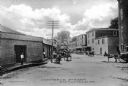
| Description: | View down Commerce Street featuring several wagons and a warehouse. Published by Parish & Simpson. |
| Date: | |
|---|---|
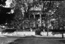
| Description: | View of Stuart Hall, a residential mansion used as the Virginia Female Institute. Chartered on January 13, 1744, the school is the state's oldest college p... |
| Date: | |
|---|---|
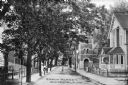
| Description: | View down Mason Street featuring Trinity Methodist Church at the Cedar Street intersection. The Gothic structure was built in 1898. Published by Parish &... |

| Date: | |
|---|---|
| Description: | View of four men and a boy walking down a narrow lane lined with homes and a picket fence. |

| Date: | |
|---|---|
| Description: | Exterior view of a classic Virgina style colonial home built by Dudley Digges in 1760. |

| Date: | |
|---|---|
| Description: | Exterior of the residence of John B. Pinnel, an old gabled home on a residential street. A Ford automobile can be seen parked on the street. Published by T... |

| Date: | 1957 |
|---|---|
| Description: | U.S.S. Wisconsin docked on the Hudson River at Norfolk, during decommissioning ceremonies. |

| Date: | 11 1957 |
|---|---|
| Description: | Uniformed sailors gathered on the deck of the U.S.S. Wisconsin during decommissioning ceremonies. |

| Date: | 1862 |
|---|---|
| Description: | This map shows the region of southeastern Virginia which served as the setting for the Peninsular Campaign of 1862. A few battle sites are marked by crosse... |

| Date: | 1864 |
|---|---|
| Description: | This colored map shows cities, rail lines, and geographic features in eastern Virginia. Circles around Richmond at 10 mile intervals indicate distances fro... |

| Date: | 1864 |
|---|---|
| Description: | This map of the battlefield at Wilderness, Virginia, illustrates the Union positions in blue and Confederate positions in red. Roads, railroads, vegetation... |

| Date: | 1864 |
|---|---|
| Description: | This battlefield map of the Battle of Totopotomoy Creek, also known as the Battle of Bethesda Church, shows the railroads, roads, vegetation and topography... |

| Date: | 1864 |
|---|---|
| Description: | This battlefield map of the Battle of Totopotomoy Creek, also known as the Battle of Bethesda Church, shows the railroads, roads, vegetation and topography... |

| Date: | 1864 |
|---|---|
| Description: | This map of the area of the First Battle of Bull Run shows military positions and troop movements as well as the names of landowners, vegetation and land u... |

| Date: | 1864 |
|---|---|
| Description: | This map created during the Civil War indicates Confederate fortifications, houses, names of residents, towns, roads, railroads, relief by hachures, draina... |

| Date: | 1865 |
|---|---|
| Description: | This map of the battlefield at Spotsylvania Courthouse illustrates the Union positions in blue and Confederate positions in red. Roads, railroads, vegetati... |

| Date: | 1865 |
|---|---|
| Description: | This map of the battlefield at Five Forks, Va., shows Union and Confederate positions, roads, drainage, vegetation, relief by hachures, and names of reside... |

| Date: | 1865 |
|---|---|
| Description: | Map extends from Harper's Ferry in the north to Petersburg in the south and from Lexington east to Heathsville. The routes of the II, V, VI, IX, XVIII, and... |
If you didn't find the material you searched for, our Library Reference Staff can help.
Call our reference desk at 608-264-6535 or email us at:

