 Filter: Categories of Wisconsin Historical Images
Filter: State of Virginia
Filter: Subject of water
Filter: Subject of battles
Filter: Categories of Wisconsin Historical Images
Filter: State of Virginia
Filter: Subject of water
Filter: Subject of battles
| Date: | |
|---|---|
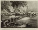
| Description: | Currier & Ives lithograph of the fall of Richmond, April 2, 1865. |
| Date: | |
|---|---|
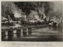
| Description: | "The Evacuation of Richmond Virginia. By the Government of the Southern Confederacy on the Night of April 2nd 1865." Before evacuating, the Confederates se... |
| Date: | |
|---|---|
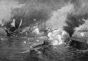
| Description: | A painting of 'The Battle Between the Monitor and the Merrimac.' The work commemorates the Battle of Hampton Roads, fought on March 8–9, 1862, and depicts ... |

| Date: | 1864 |
|---|---|
| Description: | This map of the battlefield on the North Anna River at Hanover Junction illustrates the Union positions in blue and Confederate positions in red. Roads, ra... |

| Date: | 1864 |
|---|---|
| Description: | This map of the area of the First Battle of Bull Run shows military positions and troop movements as well as the names of landowners, vegetation and land u... |

| Date: | 1862 |
|---|---|
| Description: | This map shows the plan of the siege of Yorktown and the Battle of Williamsburg. The map also shows fortifications, towns, roads, houses, names of resident... |

| Date: | 1865 |
|---|---|
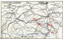
| Description: | This map shows U.S. cavalry positions in yellow, Confederate infantry positions in blue, and Confederate cavalry positions in red. The map also shows roads... |

| Date: | 1781 |
|---|---|
| Description: | Map of the southern portion of the Chesapeake Bay and surrounding lands. It shows counties, a few cities and towns, forts, roads, islands, topographical fe... |
| Date: | 1909 |
|---|---|
| Description: | Map showing operations in Virginia during Wilson's Raid. |
If you didn't find the material you searched for, our Library Reference Staff can help.
Call our reference desk at 608-264-6535 or email us at: