 Filter: Type of Map or Atlas
Filter: Creator Name of Unknown
Filter: Type of Map or Atlas
Filter: Creator Name of Unknown

| Date: | |
|---|---|
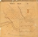
| Description: | An ink and water color on paper, hand-drawn map showing the section divisions in the southern half of the Janesville Township (Township 3 North, Range 12 E... |

| Date: | 1896 |
|---|---|
| Description: | A hand-colored Map of Jefferson County, Wisconsin, shows township and section divisions, towns, villages and post offices, rural residents, railroads, road... |

| Date: | 1900 |
|---|---|
| Description: | A map of Jefferson County, Wisconsin, that identifies named hills, other points of interest, and the Lake Mills moraine system in the county and identifies... |

| Date: | |
|---|---|
| Description: | A brochure and map of Jefferson County, Wisconsin, that includes illustrations and a location map. Descriptions of points of interest are printed on the op... |

| Date: | |
|---|---|
| Description: | An ink and watercolor on tracing map showing the sections and surveyed lots in the vicinity of the Rock and Crawfish rivers in the central and eastern port... |

| Date: | |
|---|---|
| Description: | An ink and pencil on paper hand-drawn map showing sections and landowners along the north bank of the Fox River in the towns of Grand Chute and Vandenbroek... |

| Date: | 1946 |
|---|---|
| Description: | Map of Kewaunee County, Wisconsin, shows towns, cities and villages, roads and highways, railroads, schools, lighthouses, place names, town divisions, comm... |

| Date: | 1899 |
|---|---|
| Description: | Overhead map of the Stanley McCormick's Riven Rock estate in El Montecito, Santa Barbara, California. The map shows the placement of dwellings and fields, ... |

| Date: | 1899 |
|---|---|
| Description: | A map showing the shoreline of a portion of El Montecito, Santa Barbara County, California. The map shows properties along the Pacific Ocean, and may have ... |

| Date: | 1970 |
|---|---|
| Description: | A map of parks of Kewaunee County, Wisconsin, showing the fishing spots, lakes and parks in the area, it also provides a location map of the area. On the ... |

| Date: | 1836 |
|---|---|
| Description: | A series of ink, watercolor, and pencil on paper, hand-drawn maps of the townships of Darlington and Gratiot in Lafayette County, Wisconsin, showing the to... |

| Date: | 1830 |
|---|---|
| Description: | An ink on paper, hand-drawn map, showing the wagons roads that travel through Lafayette County, traveling between Galena, Illinois, and Mineral Point, Wisc... |

| Date: | 1990 |
|---|---|
| Description: | A tourist map of Lafayette County, Wisconsin, that shows the locations of motels, camping, municipal parks, cheese factory tours, waysides, and golf course... |

| Date: | 1909 |
|---|---|
| Description: | A map of Langlade County, Wisconsin that shows townships and ranges, towns, cities and villages, wagon roads, churches, schools, sawmills, town halls, chee... |

| Date: | 1941 |
|---|---|
| Description: | A tourist map of Marinette County, Wisconsin that includes indexes of the lakes and rivers in the county which also identify the fish present, a list of ra... |

| Date: | 1970 |
|---|---|
| Description: | A map showing highlighted snowmobile trails, ice crossings, and supporting businesses in the towns of Stephenson and Silver Cliff in Marinette County and ... |
| Date: | |
|---|---|
| Description: | This manuscript map shows the township and range system and lakes and streams in the vicinity of the Fox River, Puckaway Lake, and Buffalo Lake in the town... |

| Date: | 1900 |
|---|---|
| Description: | A Hydrographic map of Lake Mendota that shows the depths of the lake through contour lines and cross sections of the lake. Also shown in the map are the ad... |

| Date: | 1993 |
|---|---|
| Description: | A series of three maps showing the lands of the Menominee, the first of these three maps shows the present-day Menominee Indian Reservation. Highways and r... |
If you didn't find the material you searched for, our Library Reference Staff can help.
Call our reference desk at 608-264-6535 or email us at:
