Filter: Creator Name of Unknown
Filter: Year of 1800-1899
Filter: Year of 1820-1829
Filter: Creator Name of Unknown
Filter: Year of 1800-1899
Filter: Year of 1820-1829

| Date: | 1823 |
|---|---|
| Description: | In 1823 U.S. Army major Stephen H. Long led an expedition of scientific, trade, and military investigation up the Mississippi River and the Red River of th... |
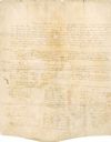
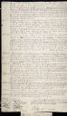
| Date: | 01 08 1825 |
|---|---|
| Description: | The first page of the handwritten treaty between the Stockbridge and Munsee Indians. |
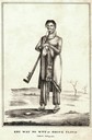
| Date: | 1827 |
|---|---|
| Description: | Lithographic portrait of Key-Way-No-Wut or Going Cloud, the war chief of the Lac du Flambeau band of Chippewa smoking a pipe. |
| Date: | 08 18 1821 |
|---|---|
| Description: | Green Bay Treaty, August 18, 1821. The treaty is signed by the chiefs of the six Indian nations for the possession of lands near the Fox River to the Winne... |
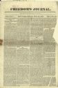
| Date: | 06 22 1827 |
|---|---|
| Description: | Front page of "Freedom's Journal," Volume 1, #15. |

| Date: | 1821 |
|---|---|
| Description: | Plan of the settlement of Green Bay. |
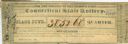
| Date: | 1826 |
|---|---|
| Description: | Connecticut State Lottery ticket for the benefit of the Bishop's Fund. |
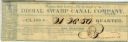
| Date: | 1827 |
|---|---|
| Description: | Virginia State Lottery ticket for the benefit of the Dismal Swamp Canal Company. |

| Date: | 1821 |
|---|---|
| Description: | A topographical view of the site of Fort Crawford. |

| Date: | 1829 |
|---|---|
| Description: | Photoprint of Crawford County lead district map. |
| Date: | 08 19 1825 |
|---|---|
| Description: | Beginning page of the Treaty between the United States and the Chippewa, Sauk, Fox, Menominee, Iowa, Sioux, Winnebago and a portion of the Ottawa, Chippewa... |
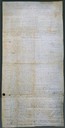
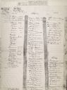
| Date: | 08 19 1825 |
|---|---|
| Description: | Fourth page of the Treaty between the United States and the Chippewa, Sauk, Fox, Menominee, Iowa, Sioux, Winnebago and a portion of the Ottawa, Chippewa, a... |
| Date: | 08 19 1825 |
|---|---|
| Description: | Second page of the Treaty between the United States and the Chippewa, Sauk, Fox, Menominee, Iowa, Sioux, Winnebago and a portion of the Ottawa, Chippewa, a... |
| Date: | 08 19 1825 |
|---|---|
| Description: | Third page of the Treaty between the United States and the Chippewa, Sauk, Fox, Menominee, Iowa, Sioux, Winnebago and a portion of the Ottawa, Chippewa, an... |

| Date: | 1825 |
|---|---|
| Description: | Portion of a map showing a survey of Lake Superior including the River St. Louis. |
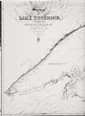
| Date: | 1825 |
|---|---|
| Description: | Survey of Lake Superior including Wisconsin and Minnesota. |
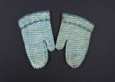
| Date: | 1827 |
|---|---|
| Description: | Baby mittens knitted of blue and white wool yarn. |

| Date: | 02 1823 |
|---|---|
| Description: | A map featuring the North American expedition from Pittsburgh to the Rocky Mountains led by Edwin James. |
If you didn't find the material you searched for, our Library Reference Staff can help.
Call our reference desk at 608-264-6535 or email us at: