 Filter: Community of Hustisford
Filter: Creator Name of Unknown
Filter: Community of Hustisford
Filter: Creator Name of Unknown

| Date: | 1910 |
|---|---|
| Description: | Left half of a plat map of Hustisford in Dodge County. |

| Date: | 1910 |
|---|---|
| Description: | The right half of a plat map of Hustisford in Dodge County. |

| Date: | 11 15 1957 |
|---|---|
| Description: | This map shows single family residence district, business district, and manufacturing district, as well as block and lot numbers, Hustis Homestead, gravel ... |
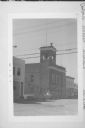
| Date: | 08 1974 |
|---|---|
| Description: | Exterior view of Hustisford City Hall at 210 South Lake Street. There is a siren on top of the building. |
If you didn't find the material you searched for, our Library Reference Staff can help.
Call our reference desk at 608-264-6535 or email us at:
