Filter: Community of Superior
Filter: Subject of streets
Filter: Community of Superior
Filter: Subject of streets
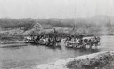
| Date: | 1880 |
|---|---|
| Description: | Crossing a river on the way to Vermillion Lake in the early 1880's, before the building of any railroads in that part of the country. The teams were part o... |
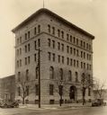
| Date: | 1937 |
|---|---|
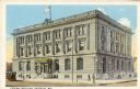
| Description: | Exterior view across street toward the Courthouse and Post Office. Caption reads: "U.S. Courthouse and Post Office, Superior, Wis." |
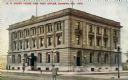
| Date: | 1909 |
|---|---|
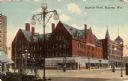
| Description: | View across street toward the Superior Hotel on a street corner. Caption reads: "Superior Hotel, Superior, Wis." |
| Date: | 1915 |
|---|---|
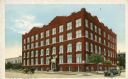
| Description: | Exterior view of the Young Men's Christian Association building on a street corner. Caption reads: "Y. M. C. A. Superior, Wis." |
| Date: | 1889 |
|---|---|
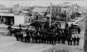
| Description: | View of Superior, with a large group of men posting in a road in the foreground, and various buildings behind them. |
| Date: | 1885 |
|---|---|
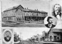
| Description: | Collage of images featuring a view of the Nicollet House, a view down a main street, and portrait photographs of O.K. Hall, James Kane, and August Zachau. |
| Date: | 1915 |
|---|---|
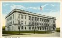
| Description: | Exterior view across street towards the Federal Building. Caption reads: "Federal Building, Superior, Wis." |
| Date: | 1915 |
|---|---|
| Description: | Exterior view of the Douglas County Courthouse. Caption reads: "Court House, Superior, Wis." |
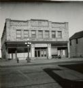
| Date: | 1940 |
|---|---|
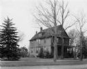
| Description: | Exterior view of the Butler home. |

| Date: | |
|---|---|
| Description: | Letterhead of the City of Superior, Wisconsin, with a three-quarter view of City Hall, printed in blue-green ink, with additional text in brown ink, by Typ... |

| Date: | 1890 |
|---|---|
| Description: | This map of Superior shows labeled streets, railroads, docks, city wards, and the state line. Relief is shown by hachures. Below the title reads: "Bedford ... |

| Date: | 1890 |
|---|---|
| Description: | This map of Superior shows city wards, bays, docks, some businesses and points of interest. Relief is shown by hachures. The back of the map features a typ... |

| Date: | 1898 |
|---|---|
| Description: | This map of Superior shows city wards, bays, docks, and some businesses and points of interest. Relief is shown by hachures. The map probably came from a C... |

| Date: | 1898 |
|---|---|
| Description: | This map of Duluth and Superior show lands that "will be for sale soon" in portions of Douglas County, Wisconsin and Saint Louis County, Minnesota. The map... |

| Date: | 1934 |
|---|---|
| Description: | This map shows industrial points of interest in Superior. The top of the map reads: "Superior, Douglas County, Wisconsin, as this Industrial Tour map indic... |

| Date: | 1951 |
|---|---|
| Description: | This map of Superior shows labeled streets, waterways, railroads, and company ownership of docks. |

| Date: | 1860 |
|---|---|
| Description: | This map of Superior is oriented with north to the upper left. Relief is shown by hachures and water depths are shown by soundings. Lake Superior and bays ... |

| Date: | 1863 |
|---|---|
| Description: | This map of Superior shows Montgomery's Addition. An inset map shows the south west end of Lake Superior where Montgomery's Addition is located. The map re... |
If you didn't find the material you searched for, our Library Reference Staff can help.
Call our reference desk at 608-264-6535 or email us at: