 Filter: County of Dodge
Filter: Creator Name of Unknown
Filter: Subject of water
Filter: County of Dodge
Filter: Creator Name of Unknown
Filter: Subject of water

| Date: | 1907 |
|---|---|
| Description: | Buildings and storefronts in town near bridge and river. |
| Date: | |
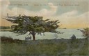
|---|---|
| Description: | Three people sitting on a bench under the old thorn apple tree at Schliewerts Island looking out at the lake. Caption reads: "Beaver Dam, Wis. Under the Ol... |

| Date: | |
|---|---|
| Description: | View of the Van Brunt plant. The Van Brunt Manufacturing Company began in 1860 when brothers George and Daniel Van Brunt patented a design for a combinatio... |
| Date: | 1905 |
|---|---|
| Description: | View from shoreline towards a river with a dam in the distance. Caption reads: "River Scene, Mayville, Wis." |

| Date: | 1910 |
|---|---|
| Description: | Left half of a plat map of Hustisford in Dodge County. |

| Date: | 1910 |
|---|---|
| Description: | The right half of a plat map of Hustisford in Dodge County. |

| Date: | 1937 |
|---|---|
| Description: | Label submitted to the state of Wisconsin for trademark registration. "Pioneer Beer, G. Weber Brewing Co." Under this in the center is a leaf with the lett... |

| Date: | 1930 |
|---|---|
| Description: | This manuscript map, likely drawn in the 1930s, shows Fox Lake, in Dodge County, Wisconsin, and the roads and resorts in the vicinity. |

| Date: | |
|---|---|
| Description: | Photographic postcard of an elevated view of a lake with boathouses along the shore and dwellings in the distance. Caption reads: "Birds Eye View from Cott... |
| Date: | |
|---|---|
| Description: | Postcard view of a dam with a mill behind it. Caption reads: "Upper Woolen Mill Dam, Beaver Dam, Wisconsin." |

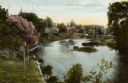
| Date: | |
|---|---|
| Description: | Colorized postcard view over water towards boats and boaters at a resort. In the background are people and boats near a pier. The resort is among trees on ... |

| Date: | 1932 |
|---|---|
| Description: | This map of Beaver Dam shows new boundary lines for wards, existing wards, roads, railroads, and rivers. Roads and Beaver Dam Lake are labeled. There are s... |

| Date: | 1870 |
|---|---|
| Description: | This map is ink and color on tracing cloth and shows Iron Ridge, the hotel and saw mill at Iron Ridge Village, Milwaukee & St. Paul Railway, plank road, an... |

| Date: | 11 15 1957 |
|---|---|
| Description: | This map shows single family residence district, business district, and manufacturing district, as well as block and lot numbers, Hustis Homestead, gravel ... |

| Date: | 1900 |
|---|---|
| Description: | This map shows landownership and buildings in the community in 1876. An inset map shows Plan of Corporation of Mayville. The upper left corner includes a b... |

| Date: | 1913 |
|---|---|
| Description: | View across water towards Elmwood Island, with lakeside homes. Caption reads: "Elmwood Island at Fox Lake, Wis." |

| Date: | 1913 |
|---|---|
| Description: | View of the Short Bridge over the Rock River at Horicon. Two men are in a small boat in the river. Caption reads: "Short Bridge, Horicon, Wis." |

| Date: | 1912 |
|---|---|
| Description: | View from shoreline toward a bridge over the Rock River. A boat with three men is passing underneath the bridge. Caption reads: "'Wood's' Bridge South of H... |

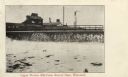
| Date: | |
|---|---|
| Description: | Elevated view of a completely burned building in downtown Horicon at the river. A cigar store is next door, and men are gathered on the bridge. |
If you didn't find the material you searched for, our Library Reference Staff can help.
Call our reference desk at 608-264-6535 or email us at:
