 Filter: County of Dodge
Filter: Subject of cities and towns
Filter: Subject of lakes
Filter: County of Dodge
Filter: Subject of cities and towns
Filter: Subject of lakes

| Date: | 1867 |
|---|---|
| Description: | Birds-eye drawing of Beaver Dam, Dodge Co., depicting street names and street layout, houses, rivers, lakes, and trees. A reference key at the bottom of th... |
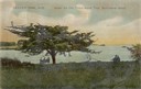
| Date: | |
|---|---|
| Description: | Three people sitting on a bench under the old thorn apple tree at Schliewerts Island looking out at the lake. Caption reads: "Beaver Dam, Wis. Under the Ol... |

| Date: | 1910 |
|---|---|
| Description: | Left half of a plat map of Hustisford in Dodge County. |

| Date: | 1896 |
|---|---|
| Description: | This late 19th-century map of Dodge County, Wisconsin, shows the township and range grid, towns, sections, cities, villages and post offices, some property... |

| Date: | 1899 |
|---|---|
| Description: | This 1899 map of Dodge County, Wisconsin, shows the township and range grid, towns, sections, cities and villages, roads, railroads, post offices, cemeteri... |

| Date: | |
|---|---|
| Description: | Photographic postcard of an elevated view of a lake with boathouses along the shore and dwellings in the distance. Caption reads: "Birds Eye View from Cott... |

| Date: | 1932 |
|---|---|
| Description: | This map of Beaver Dam shows new boundary lines for wards, existing wards, roads, railroads, and rivers. Roads and Beaver Dam Lake are labeled. There are s... |

| Date: | 1940 |
|---|---|
| Description: | This map of Beaver Dam pictorially shows the history of the town. The map was made for the 100th anniversary celebration of Beaver Dam in 1941. The map inc... |

| Date: | 1952 |
|---|---|
| Description: | This map of Beaver Dam shows state trunk highway system, county trunk highway system, town roads, rivers, and Beaver Dam Lake and includes an additional at... |

| Date: | 11 15 1957 |
|---|---|
| Description: | This map shows single family residence district, business district, and manufacturing district, as well as block and lot numbers, Hustis Homestead, gravel ... |

| Date: | 1961 |
|---|---|
| Description: | This map shows the lake, clubs, resorts, motels, school house, public approaches, and public parks. The back of map includes advertisements and text. |

| Date: | 1891 |
|---|---|
| Description: | This map shows soft marshland, water channels, solid ground, club boundary and shooting boxes. Big Lake, First Channel, Second Channel, Fout Mile Pond, Mal... |
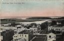
| Date: | 1912 |
|---|---|
| Description: | Bird's-eye view of downtown Fox Lake, with a marshy area and the lake in the background. Caption reads: "Bird's-eye View, Fox Lake, Wis." |
If you didn't find the material you searched for, our Library Reference Staff can help.
Call our reference desk at 608-264-6535 or email us at:
