Filter: County of Dodge
Filter: Subject of industries
Filter: Subject of land
Filter: County of Dodge
Filter: Subject of industries
Filter: Subject of land
| Date: | 1900 |
|---|---|
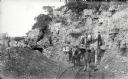
| Description: | Visitors, dressed in their Sunday best, contrast with the rough garb of the miners. Left to right, miners were: Charles Kanass, Robert "Beaver" Smith (hold... |
| Date: | 02 05 1978 |
|---|---|
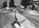
| Description: | "Union Cemetery — The graves are awash in snow in the aftermath of the late January snowstorm." |

| Date: | 06 1988 |
|---|---|
| Description: | "This photo of the pipeline looks north on the Larry Luhn farm. The opposite looks south from the same point on the farm." |

| Date: | 06 1988 |
|---|---|
| Description: | "Shirley Widmer stands near a gas line on Luhn farm." |

| Date: | 06 1995 |
|---|---|
| Description: | "Joe Lackas works on the playground behind the Theresa Learning Center." |

| Date: | 03 17 1997 |
|---|---|
| Description: | "Work begins on the new water tower south of Theresa." |

| Date: | 03 17 1997 |
|---|---|
| Description: | "A very muddy road leads to the water tower site." |

| Date: | 03 19 1997 |
|---|---|
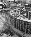
| Description: | "Newly poured cement is covered up as a protection for the very cold nights." |

| Date: | 03 21 1997 |
|---|---|
| Description: | "The base of the new water tower is now taking shape." |

| Date: | 04 17 1997 |
|---|---|
| Description: | "Shirley Widmer poses on the now completed water tower base." |

| Date: | 04 30 1997 |
|---|---|
| Description: | "At the fire on the opposite page [Page 26], this 3/4 full, 500 gallon propane tank exploded and was propelled 1/2 mile to this location on the Jim & Donna... |

| Date: | 1997 |
|---|---|
| Description: | "Looking southeast of the water tower are Carl Benter rental units." |

| Date: | 1921 |
|---|---|
| Description: | Relief shown by contours and spot heights. Includes inset location map. "Contour interval 10 feet." "Advance sheet, subject to correction." "Surveyed in 19... |

| Date: | 1986 |
|---|---|
| Description: | Shirley and Alphonse Beck are dwarfed by this large Red Oak in Beck's Woods along North Pole Road, near the Theresa Station. The tree measures 12 feet in c... |

| Date: | 1870 |
|---|---|
| Description: | This map is ink and color on tracing cloth and shows Iron Ridge, the hotel and saw mill at Iron Ridge Village, Milwaukee & St. Paul Railway, plank road, an... |

| Date: | 1955 |
|---|---|
| Description: | Elna Krueger stands with another woman and a man while cutting firewood using a belt-driven saw by a tractor in a field in the background on the left. The... |
If you didn't find the material you searched for, our Library Reference Staff can help.
Call our reference desk at 608-264-6535 or email us at: