 Filter: County of Dodge
Filter: Subject of lakes
Filter: County of Dodge
Filter: Subject of lakes

| Date: | |
|---|---|
| Description: | Photographic postcard of an elevated view of a lake with boathouses along the shore and dwellings in the distance. Caption reads: "Birds Eye View from Cott... |

| Date: | |
|---|---|
| Description: | Colorized postcard view over water towards boats and boaters at a resort. In the background are people and boats near a pier. The resort is among trees on ... |

| Date: | 1932 |
|---|---|
| Description: | This map of Beaver Dam shows new boundary lines for wards, existing wards, roads, railroads, and rivers. Roads and Beaver Dam Lake are labeled. There are s... |

| Date: | 1940 |
|---|---|
| Description: | This map of Beaver Dam pictorially shows the history of the town. The map was made for the 100th anniversary celebration of Beaver Dam in 1941. The map inc... |

| Date: | 1952 |
|---|---|
| Description: | This map of Beaver Dam shows state trunk highway system, county trunk highway system, town roads, rivers, and Beaver Dam Lake and includes an additional at... |
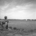
| Date: | 1958 |
|---|---|
| Description: | Glenn Oestreich standing along the shore of a lake. Another person sits on the curved shoreline in the background on the left. There are farm buildings on ... |

| Date: | 11 15 1957 |
|---|---|
| Description: | This map shows single family residence district, business district, and manufacturing district, as well as block and lot numbers, Hustis Homestead, gravel ... |

| Date: | 1961 |
|---|---|
| Description: | This map shows the lake, clubs, resorts, motels, school house, public approaches, and public parks. The back of map includes advertisements and text. |

| Date: | 1891 |
|---|---|
| Description: | This map shows soft marshland, water channels, solid ground, club boundary and shooting boxes. Big Lake, First Channel, Second Channel, Fout Mile Pond, Mal... |

| Date: | |
|---|---|
| Description: | View across water towards the Grand View Resort on the shores of Fox Lake. Several people are sitting in rowboats lined up at the shoreline. Other guests a... |
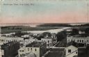
| Date: | 1912 |
|---|---|
| Description: | Bird's-eye view of downtown Fox Lake, with a marshy area and the lake in the background. Caption reads: "Bird's-eye View, Fox Lake, Wis." |

| Date: | 1913 |
|---|---|
| Description: | View across water towards Elmwood Island, with lakeside homes. Caption reads: "Elmwood Island at Fox Lake, Wis." |
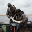
| Date: | |
|---|---|
| Description: | Two men are collecting northern pike spawn on Fox Lake. One man is standing and holding the pike's head, while the other is sitting in a chair with a conta... |
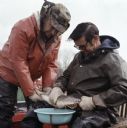
| Date: | |
|---|---|
| Description: | Close-up view of two men collecting northern pike spawn on Fox Lake. One man is standing and holding the pike's head, while the other man is sitting in a c... |
If you didn't find the material you searched for, our Library Reference Staff can help.
Call our reference desk at 608-264-6535 or email us at: