Filter: County of Dodge
Filter: Subject of land
Filter: County of Dodge
Filter: Subject of land
| Date: | 1900 |
|---|---|
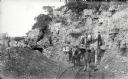
| Description: | Visitors, dressed in their Sunday best, contrast with the rough garb of the miners. Left to right, miners were: Charles Kanass, Robert "Beaver" Smith (hold... |

| Date: | 1885 |
|---|---|
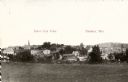
| Description: | Bird's-eye map of Hustisford. |
| Date: | 1943 |
|---|---|
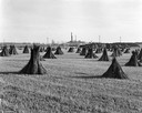
| Description: | Field of shocked hemp with stock pile, and the J. Leroy Farmer Hemp Mill in the background. |
| Date: | 1912 |
|---|---|
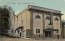
| Description: | Exterior view of the Davison Theater. Caption reads: "Davison Theatre, Beaver Dam, Wis." |
| Date: | |
|---|---|
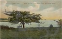
| Description: | Three people sitting on a bench under the old thorn apple tree at Schliewerts Island looking out at the lake. Caption reads: "Beaver Dam, Wis. Under the Ol... |
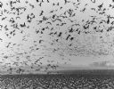
| Date: | 1972 |
|---|---|
| Description: | View of Canadian geese on the ground and in flight in Horicon Marsh. |
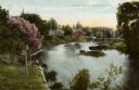
| Date: | 1905 |
|---|---|
| Description: | View from shoreline towards a river with a dam in the distance. Caption reads: "River Scene, Mayville, Wis." |
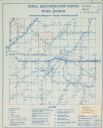
| Date: | |
|---|---|
| Description: | Rural electrification map of Dodge county in Elba township. Title at top reads: "Rural Electrification Survey by Work Division of Wisconsin Emergency Relie... |
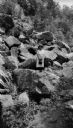
| Date: | 1923 |
|---|---|
| Description: | A young woman (probably a member or friend of the Brandel family) posing on a large rock formation surrounded by boulders. |

| Date: | 1910 |
|---|---|
| Description: | Left half of a plat map of Hustisford in Dodge County. |

| Date: | 1910 |
|---|---|
| Description: | The right half of a plat map of Hustisford in Dodge County. |
| Date: | 2004 |
|---|---|
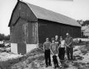
| Description: | The 6th generation of Keups now live on this farm. The property was purchased by David Keup in 1867. It was passed on to Martin, Herman, William, and now G... |
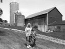
| Date: | 2004 |
|---|---|
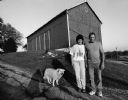
| Description: | Pam Donald and her children, Joey, Jimmy and Mary, live at N8914 N. Pole Road (Section 11). |
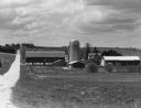
| Date: | 2004 |
|---|---|
| Description: | Karen Huettner and son, Kevin, live at N7561 Hwy 175 (Section 36). |
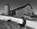
| Date: | 2004 |
|---|---|
| Description: | This barn is at W487 Zion Church Rd (Section 26). Allen and Mary Beth Eilbes and sons Michael, Andrew and Mathew (by age) live here. |
| Date: | 2004 |
|---|---|
| Description: | Ken and Sandy Gerlach live at N8684 Bancroft Rd (Section 15). |
| Date: | 2004 |
|---|---|
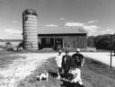
| Description: | The Donald property is located on a very high hill. The old silo dates to 1911. The Department of Natural Resources owns and uses the old barn. |
If you didn't find the material you searched for, our Library Reference Staff can help.
Call our reference desk at 608-264-6535 or email us at: