Filter: County of La Crosse
Filter: Subject of architecture
Filter: Year of 1800-1899
Filter: County of La Crosse
Filter: Subject of architecture
Filter: Year of 1800-1899

| Date: | 1867 |
|---|---|
| Description: | Bird's-eye map of La Crosse with nine insets of residences, schools, and the Court House and Jail. |
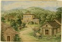
| Date: | 1859 |
|---|---|
| Description: | Due to rainy weather, Hölzlhuber stayed a night in the home of Heinrich Cordes, who had purchased his land from an Irishman and built "a pretty brick house... |
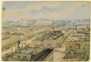
| Date: | 04 1860 |
|---|---|
| Description: | Accompanying this sketch is Hölzlhuber's description of his last foray from Milwaukee before leaving America. "Before my return to Europe, D. Brandis, the ... |
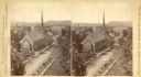
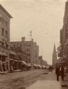
| Date: | 1880 |
|---|---|
| Description: | Stereograph of an elevated view of the Congregational Church. View is from the high school looking down Main Street. |
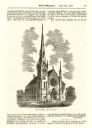
| Date: | 06 26 1869 |
|---|---|
| Description: | An engraving from the Billed-Magazine of the First Congregational Church. |

| Date: | 1890 |
|---|---|
| Description: | A large group of Brewery workers posing outside of Gund's Brewery in La Crosse. In the front of the group two men are seated at a table with a large stein ... |

| Ever wonder why beer is so popular in Wisconsin? Wisconsin history is full of breweries and beer. |
| Photographs of Public Libraries in Wisconsin |
|---|
| Learn about how the Wisconsin Free Library Commission helped to establish and improve free public libraries in Wisconsin. |

| Date: | 1800 |
|---|---|
| Description: | This map of North La Crosse is ink and pencil on paper and shows lot ownership and buildings. |

| Date: | 1859 |
|---|---|
| Description: | This map show plats including plat names, plat numbers, and some lot owner's names. Relief is shown by hachures. The map includes line drawings of Juneau B... |

| Date: | 1874 |
|---|---|
| Description: | This map has relief shown by hachures and includes 7 inset maps of additions and subdivisions with varying scales. Also includes index of additions and loc... |

| Date: | 1886 |
|---|---|
| Description: | This map has relief shown by hachures and includes a list of plats in order of date of record, laws which vacate plats, plats not shown as upon the county ... |

| Date: | 1888 |
|---|---|
| Description: | This map has relief shown by hachures and features inset maps of a plat of E.D. Clinton and Blackwell’s add’n to the City of La Crosse. Wards (1-10) shaded... |

| Date: | 1857 |
|---|---|
| Description: | This map shows section corners, quarter section corners, foundry, steam saw mill, steam grist mill, planning mill, court house, baptist church, congregatio... |

| Date: | 1883 |
|---|---|
| Description: | This map shows ward boundaries, names of additions, streets, bridges, mills, schools, religious buildings, businesses, hotels, railroads, factories, brewer... |

| Date: | 1891 |
|---|---|
| Description: | This hand-colored map shows platted additions and subdivisions, ward boundaries, schools, churches, railroads, cemeteries, parks, businesses, factories, an... |

| Date: | 10 1891 |
|---|---|
| Description: | This blueprint map shows land ownership and buildings. Text below the title reads: "The La Crosse Heights include the ridge of land with the spurs projecti... |
If you didn't find the material you searched for, our Library Reference Staff can help.
Call our reference desk at 608-264-6535 or email us at: