 Filter: FULL_DATE of 1853
Filter: Subject of land
Filter: FULL_DATE of 1853
Filter: Subject of land
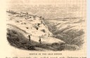
| Date: | 1853 |
|---|---|
| Description: | Engraved view of miners and hillside mines in the Lead Region. Caption reads: "Sketch of the Lead Region." |

| Date: | 1853 |
|---|---|
| Description: | Shows railroads, planned and in place. |

| Date: | 1853 |
|---|---|
| Description: | Plan no. 3. Scale 2000 feet to one inch. |

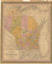
| Date: | 1853 |
|---|---|
| Description: | Wisconsin counties by color and shows railroads, common roads, canals, the state capital, county towns, townships, villages, and post offices, |

| Date: | 1853 |
|---|---|
| Description: | Southern two thirds of Wisconsin with county boundaries hand-colored in red. The map displays towns, railroads, plan roads and mines. The scale is ten mile... |

| Date: | 1853 |
|---|---|
| Description: | Railroad map outlines mid and southern Wisconsin county boundaries in red, and city/town lines are provided. Other marks include lead mines, copper mines, ... |

| Date: | 1853 |
|---|---|
| Description: | Engraved image of a boat being towed through a canal at Little Falls by a team of horses. A small town is in the background. |

| Date: | 1853 |
|---|---|
| Description: | Map covers area between the cities of Janesville and Kenosha in Rock, Walworth, and Kenosha counties for railroad routes. Lakes and counties are labelled. ... |
| Date: | 1853 |
|---|---|
| Description: | This map shows counties in pink, orange, green, and yellow. Lake Michigan and Lake Superior are labeled as well as rivers and some geographical features. M... |

| Date: | 1853 |
|---|---|
| Description: | A map of Wellfleet Harbor on Cape Cod Bay. |
If you didn't find the material you searched for, our Library Reference Staff can help.
Call our reference desk at 608-264-6535 or email us at: