 Filter: Subject of Coasts

| Date: | 1795 |
|---|---|
| Description: | Map of South Carolina showing the precincts, cities, towns, Native American villages (marked with a triangle), courthouses, roads, mountains, swamps, islan... |

| Date: | 1779 |
|---|---|
| Description: | Map of colonial Georgia showing cities, towns, Native American land and towns, forts, roads, trading paths, islands, mountains, swamps, and rivers. Annotat... |

| Date: | 1763 |
|---|---|
| Description: | Map showing the new British territories of East and West Florida following the Treaty of Paris at the end of the French and Indian War. It shows boundaries... |

| Date: | 1781 |
|---|---|
| Description: | Map of the Southeastern part of the British Colonies in North America, Gulf Coast and Caribbean. It illustrates the of the Spanish and English fleets, part... |

| Date: | 1781 |
|---|---|
| Description: | Map of the British territory of West Florida, extending from the Mississippi River to the Apalachicola River. It shows the borders, cities, towns, forts, h... |

| Date: | 1795 |
|---|---|
| Description: | Map of Georgia, with its borders extending to the Mississippi River. It shows borders, various boundary lines, counties, cities, towns, Native American lan... |

| Date: | 1761 |
|---|---|
| Description: | Map covering southern Louisiana from Lake Ponchetrain to the Golf of Mexico and from Woods Bay in the west to the islands just east of Bay St. Louis. It sh... |

| Date: | 1759 |
|---|---|
| Description: | Map of New Orleans at the start of the French & Indian War, including two inset maps entitled "The Course of the Mississipi River from Bayagoulas to the Se... |

| Date: | 1769 |
|---|---|
| Description: | Map of New Orleans at the start of the French & Indian War, including two inset maps of the Mississippi River Delta and Fort la Balise. It shows streets, r... |

| Date: | |
|---|---|
| Description: | Color postcard across water towards a rock formation. Waves are breaking against the rocks below. In the upper-right corner of the postcard are cherries on... |

| Date: | 1814 |
|---|---|
| Description: | A map of the Harbour (sic) of St. Catherine (Brazil). |

| Date: | 07 02 1920 |
|---|---|
| Description: | Alfred Holt is standing on the beach, carrying several boxes under his arm. To his right is his father W.A. Holt. A group of eight women are sitting on the... |
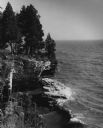
| Date: | 1962 |
|---|---|
| Description: | Pine trees at the edge of the rocky shoreline in High Cliff Park on Lake Michigan. |

| Date: | |
|---|---|
| Description: | German film critics Enno Patalas and Frieda Grafe stand on a groyne (a wooden and cement barrier) on the beach in Knokke-le-Zoute, Belgium. Grafe is highe... |

| Date: | |
|---|---|
| Description: | German film critics Enno Patalas and Frieda Grafe are seen at the beach in Knokke-le-Zoute, Belgium. The two are on a groyne (a wooden and cement barrier)... |

| Date: | |
|---|---|
| Description: | Enno Patalas and Frieda Grafe, German film critics, stand by two road signs near the beach in Knokke-le-Zoute, Belgium. Patalas stands next to a tall red,... |
If you didn't find the material you searched for, our Library Reference Staff can help.
Call our reference desk at 608-264-6535 or email us at: