 Filter: Subject of Coasts

| Date: | |
|---|---|
| Description: | Passenger side view of Scout parked on beach. The Scout has a windshield and roll bars in place, but no doors. The ocean is in the background. |

| Date: | |
|---|---|
| Description: | Passenger side view of Scout parked on dunes. The Scout has a windshield and roll bars in place, but no doors. The ocean is in the background. |

| Date: | |
|---|---|
| Description: | Three-quarter view from front of driver's side of Scout parked on beach. The Scout has a windshield and roll bars in place, but no doors. The ocean is in t... |

| Date: | |
|---|---|
| Description: | Three-quarter view from front of driver's side of Scout parked on beach. The Scout has a windshield and roll bars in place, but no doors. The ocean is in t... |

| Date: | |
|---|---|
| Description: | Driver's side view of Scout parked on beach. The Scout has a windshield and roll bars in place, but no doors. A white helmet is sitting on the driver's sea... |

| Date: | |
|---|---|
| Description: | View looking down dune towards a man wearing a helmet driving a Scout. Trees and plants are on top of the dunes. The Scout has a windshield and roll bars i... |

| Date: | |
|---|---|
| Description: | Rear view of Scout parked in dunes. Ocean in the far background. |

| Date: | 1968 |
|---|---|
| Description: | Three-quarter view from front of passenger side of red International Scout with white Traveltop. Two people are in the front seat. The sides of the Travelt... |

| Date: | 1910 |
|---|---|
| Description: | View of Table Mountain and beach from Milnerton, South Africa. People are walking on the beach. |
| Date: | 04 16 1963 |
|---|---|
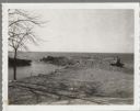
| Description: | Chaudoir Dock in Brussels. The shoreline is on the left and has rocks along its edge. In the background is Lake Michigan. |

| Date: | |
|---|---|
| Description: | Aerial view of harbors and bridge. Farm fields are on either side of the bridge. The city of Sturgeon Bay is in the distance. There are docks along the sho... |

| Date: | 1902 |
|---|---|
| Description: | This map is a chart of Milwaukee Harbor that displays local streets, bridges, roads, railroads, public buildings, businesses, factories, dry docks, parks, ... |

| Date: | 1847 |
|---|---|
| Description: | This map identifies surveyed areas of the Upper Peninsula and shows lakes, rivers, and islands in portions of Wisconsin, Minnesota, Michigan, and upper Can... |
| Date: | 1792 |
|---|---|
| Description: | This map depicts the fixed boundaries by a peace treaty between the United States and the Spanish Dominions. |
| Date: | |
|---|---|
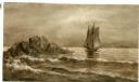
| Description: | Watercolor painting of a sailing ship on a sea or ocean. A large rock formation is on the left. |

| Date: | 1786 |
|---|---|
| Description: | One half of a four sheet nautical chart, showing the coastlines of the north-west hemisphere. The interior lands are left bare, even of basic features such... |

| Date: | 1775 |
|---|---|
| Description: | This map shows the northern Pacific Ocean along with north eastern Asia and western North America. The interior of Asia contains detailed engravings of pla... |

| Date: | 1698 |
|---|---|
| Description: | A sea chart of Hudson's Bay, Greenland, and the Canadian Arctic. This map shows rhumb lines extending from various points including two compass roses. Coas... |

| Date: | 1788 |
|---|---|
| Description: | This map shows the north western coast of North America, including the southern coast of what will be Alaska and parts of the Aleutian Islands. It includes... |

| Date: | 1777 |
|---|---|
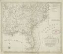
| Description: | This detailed map of the American colonies shows cities, villages, roads, mountains, lakes, rivers, swamps, counties, state boundaries, and Native American... |
If you didn't find the material you searched for, our Library Reference Staff can help.
Call our reference desk at 608-264-6535 or email us at: