 Filter: Subject of Coasts
Filter: Year of 1800-1899
Filter: Subject of Coasts
Filter: Year of 1800-1899
| Date: | 1856 |
|---|---|
| Description: | At the beginning of his journey to America, Hölzlhuber passed through the English Channel and viewed the cliffs at Dover. "We passed Beachy Head, as this p... |

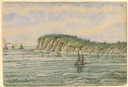
| Date: | 1856 |
|---|---|
| Description: | While passing through the English Channel in May 1856 Hölzlhuber viewed the Isle of Wight. "The island is located in the English Channel not far from Hamps... |

| Date: | 1899 |
|---|---|
| Description: | Topographical map showing ridges, water courses, boundary lines, and trails and roads near the Stanley McCormick's Riven Rock estate in El Montecito, Santa... |

| Date: | 1899 |
|---|---|
| Description: | A map showing the shoreline of a portion of El Montecito, Santa Barbara County, California. The map shows properties along the Pacific Ocean, and may have ... |

| Date: | 1847 |
|---|---|
| Description: | This map identifies surveyed areas of the Upper Peninsula and shows lakes, rivers, and islands in portions of Wisconsin, Minnesota, Michigan, and upper Can... |

| Date: | 1871 |
|---|---|
| Description: | A map of California showing railroad lines and reservations. |

| Date: | 1814 |
|---|---|
| Description: | A map of the Harbour (sic) of St. Catherine (Brazil). |
If you didn't find the material you searched for, our Library Reference Staff can help.
Call our reference desk at 608-264-6535 or email us at: