 Filter: Subject of Geology
Filter: Year of 1900-1999
Filter: Subject of Geology
Filter: Year of 1900-1999
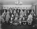
| Date: | 03 07 1930 |
|---|---|
| Description: | Group portrait of the University of Wisconsin-Madison Geology club in the Beefeaters room in Memorial Union. |
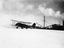
| Date: | 1938 |
|---|---|
| Description: | Curtiss-Wright Condor biplane named "William Horlick" outfitted with skis for use during Adm. Richard E. Byrd's second Antarctic expedition, 1933-35. The ... |
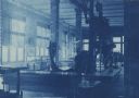
| Date: | 1910 |
|---|---|
| Description: | Cyanotype print of the interior of the Geology Museum in Science Hall on the University of Wisconsin-Madison campus. View towards corner of a room with win... |
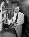
| Date: | 06 31 1953 |
|---|---|
| Description: | Professor Richard C. Emmons, of the University of Wisconsin Geology Department, who is holding a gem case of glass replicas of 10 of the largest and best-k... |

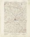
| Date: | 1920 |
|---|---|
| Description: | This map identifies the areas of the state that had been geologically surveyed or topographically surveyed, or both, as well as portions of the state still... |

| Date: | 1917 |
|---|---|
| Description: | A geological survey map that shows the sedimentary and igneous deposits in southeastern Wisconsin and south central Wisconsin, as well as the limits of gla... |

| Date: | 1917 |
|---|---|
| Description: | A geological survey map that map of southeastern Wisconsin shows the surface deposits east of the Wisconsin River, from the Illinois state line north to Ne... |

| Date: | 1931 |
|---|---|
| Description: | This U.S. Geological Survey map of Wisconsin shows counties, cities and villages, lighthouses, Indian reservations, military reservations, and bird and gam... |

| Date: | 1912 |
|---|---|
| Description: | This map is pen, ink, and pencil on tracing paper. The map was traced from U.S. Geological Survey map of Wisconsin, compiled in 1910-1911, and printed in 1... |

| Date: | 1937 |
|---|---|
| Description: | A pictorial, hydrographic map shows sailing courses, historical and contemporary coastal attractions, roads, and the contour depths of Green Lake, Wisconsi... |
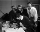
| Date: | 03 26 1957 |
|---|---|
| Description: | George Hanson (seated foreground center), state geologist, peers into a microscope while examining a diamond. Leaning in to look on are (left to right) Pro... |

| Professor, University President, Geologist and Author |
|---|
| Discover the history of professor, university president, geologist and author, Thomas Chrowder Chamberlin, who establishing the university extension. |

| Date: | 1902 |
|---|---|
| Description: | This map is watercolor and pen on paper and relief shown by contours. The map reads: "Contour interval 10 feet." Shown on the map are geological features a... |

| Date: | 03 1965 |
|---|---|
| Description: | Keith Brigham is shown checking the U.S. Geological Survey stream gauging station located at the Yahara river locks on Lake Waubesa near McFarland. |

| Date: | 1904 |
|---|---|
| Description: | This blue line print map includes 4 cross sections with relief shown by contours and spot heights. The topography was taken from the United States Geologic... |

| Date: | 1910 |
|---|---|
| Description: | This map shows the Soo Line railroad and Arpin Hardwood Lumber Company lands in red. The top margin of the map reads: "Wisconsin, the safest state in the U... |
| Date: | 1955 |
|---|---|
| Description: | This set of 32 maps and an index show the (then) proposed route of the Wisconsin Turnpike. The index shows the entire route of the turnpike, and the major ... |
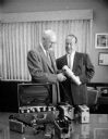
| Date: | 08 09 1957 |
|---|---|
| Description: | Richard C. Emmons (left), Professor of Geology at U.W., being presented thirteen Geiger counters and scintillation counters by E.L. Diener, manager of the ... |
If you didn't find the material you searched for, our Library Reference Staff can help.
Call our reference desk at 608-264-6535 or email us at: