Filter: Subject of Wisconsin River (Wis.)
Filter: Year of 1800-1899
Filter: Year of 1890-1899
Filter: Subject of Wisconsin River (Wis.)
Filter: Year of 1800-1899
Filter: Year of 1890-1899
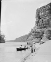
| Date: | 1897 |
|---|---|
| Description: | A view of Lone Rock from below, with a canoe on the left-hand side. |

| Date: | 1891 |
|---|---|
| Description: | Bird's-eye map of Wausau, looking north with ninety-eight businesses, industries, churches, schools, and civic buildings identified in location key below i... |
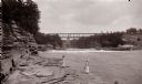
| Date: | 1890 |
|---|---|
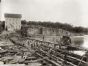
| Description: | Below Kilbourn log dam, 1890s. Two girls are standing on the edge of the river. There is a bridge in the background. |
| Date: | 07 16 1899 |
|---|---|
| Description: | View along sandy shoreline towards the Bennett family on the beach at High Rock. Ashley and Helen are in the boat, and Miriam and Ruth are standing on the ... |
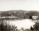
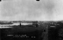
| Date: | 1890 |
|---|---|
| Description: | Elevated view looking up the Wisconsin River, with Wausau in the background. There are railroad cars on a bridge on the right. |
| Date: | 1898 |
|---|---|
| Description: | Elevated view of the Jackson Milling Company, the Green Bay railroad tracks, and the Wisconsin Central railroad tracks. Caption reads: "Birdseye View of Ri... |
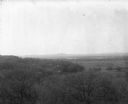
| Date: | 1896 |
|---|---|
| Description: | Elevated view. Caption on negative sleeve reads: "Black Hawk Battlefield. Wis. Heights. 'Looking it of west across river' [sic] c. 1896. Mrs. Charle... |
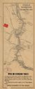
| Date: | 1891 |
|---|---|
| Description: | This late 19th century map of the Dells of the Wisconsin River shows the geographic features and topography of the area. Kilbourn City (present day Wiscons... |
| Date: | 1895 |
|---|---|
| Description: | Munger's Mill and dam, with men standing on and around the dam. |

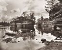
| Date: | 1894 |
|---|---|
| Description: | Panoramic view from shoreline of the Wisconsin River in the Wisconsin Dells as seen from the "Old Dell House." A canoe is visible on the shore on the far r... |

| Date: | 1894 |
|---|---|
| Description: | Panoramic view from shoreline of the Wisconsin River in the Wisconsin Dells. A sandy beach area is on the right, and rock formations are on both sides of t... |

| Date: | 1896 |
|---|---|
| Description: | Elevated panoramic view of a section of the Wisconsin Dells and the Wisconsin River visible from the "Sliding Rock." In the lower left hand corner the word... |

| Date: | 1896 |
|---|---|
| Description: | Section 5 of 12, this bicycle road map features Wisconsin bicycle routes in the counties of La Crosse, Monroe, Vernon, Crawford, Richland, Sauk, Juneau, an... |

| Date: | 1890 |
|---|---|
| Description: | Elevated view of men working on lumber rafts on the Wisconsin River. |
| Date: | 1895 |
|---|---|
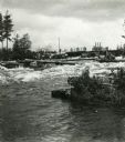
| Description: | Crew of river drivers moving logs off of rocks below a dam probably on the Wisconsin River. |
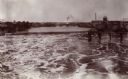
| Date: | 1890 |
|---|---|
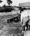
| Description: | Log driving crew maneuvering logs through rapids below a dam, probably on the Wisconsin River. |

| Date: | 1899 |
|---|---|
| Description: | This color map, originally published in the Smithsonian Institution Bureau of American Ethnology's 18th annual report, shows the Indian land cessions in Wi... |

| Date: | 1896 |
|---|---|
| Description: | A map showing the Wisconsin Central Railroad lines in Wisconsin, northern Illinois, eastern Minnesota, and Michigan’s Upper Peninsula. The area of the map ... |
| Date: | 1890 |
|---|---|
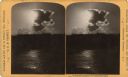
| Description: | Sunlight shining through a cloud, illuminating the water below. "Text at right: "Wanderings Among the Wonders and Beauties of Wisconsin Scenery." |
If you didn't find the material you searched for, our Library Reference Staff can help.
Call our reference desk at 608-264-6535 or email us at: