 Filter: Subject of airports
Filter: Subject of streets
Filter: Subject of airports
Filter: Subject of streets

| Date: | 1900 |
|---|---|
| Description: | This map of Three Lakes shows forest fire lookout towers, picnic grounds, an airport, roads, and railroad. The map features text boxes on the Village of Th... |

| Date: | 1970 |
|---|---|
| Description: | This map is intended for tourists of La Crosse. The cover features images of farms and natural land and reads: "friends are but strangers... we have yet to... |

| Date: | 1929 |
|---|---|
| Description: | This is a blue line print map that shows local streets, railroads, local businesses, schools, parks, cemeteries, the airport, the state capitol, the Univer... |

| Date: | 05 16 1994 |
|---|---|
| Description: | The front side of this map shows roads, highways, the Wisconsin River, Stevens Point Airport, and surrounding towns. A street index is included along the r... |

| Date: | 1966 |
|---|---|
| Description: | This blue line print shows existing and proposed streets, docks, company-owned land, railroads and railroad yards, parks, and municipal airport. |

| Date: | 1957 |
|---|---|
| Description: | This colored road map shows automobile roads in Wisconsin as well as portions of nearby states. The map is organized such that a single map of Wisconsin is... |

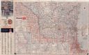
| Date: | 1959 |
|---|---|
| Description: | This colored road map shows roads in Wisconsin as well as portions of nearby states. Information on the quality and type of any road shown (expressways, St... |

| Date: | 1962 |
|---|---|
| Description: | This colored road map shows roads in Wisconsin as well as portions of nearby states. The map is organized such that a single map of Wisconsin is divided on... |
| Date: | 1962 |
|---|---|
| Description: | This colored road map shows roads in Wisconsin as well as portions of nearby states. The map is organized such that a single map of Wisconsin is divided on... |
| Date: | 1963 |
|---|---|
| Description: | This colored road map shows automobile roads in Wisconsin as well as portions of nearby states. The map is organized such that a single map of Wisconsin is... |

| Date: | 1965 |
|---|---|
| Description: | This colored road map shows automobile roads in Wisconsin as well as portions of nearby states. Information on the quality and type of any road shown (inte... |

| Date: | 1965 |
|---|---|
| Description: | Exterior view of the main terminal of the Madison Airport. Automobiles are parked along the curb. |

| Date: | 1977 |
|---|---|
| Description: | Front end view of Bob Bender's flagship cab named "Nellie," a shiny black 1956 Cadillac Fleetwood, at the Dane County Regional Airport. The straight on ang... |

| Date: | 1977 |
|---|---|
| Description: | Back end view of Bob Bender's flagship cab named "Nellie," a shiny black 1956 Cadillac Fleetwood, parked at the Dane County Regional Airport. The metal emb... |

| Date: | 1977 |
|---|---|
| Description: | Three-quarter view from front left of Bob Bender sitting in the driver's seat behind the wheel of his cab named "Nellie," a 9-passenger shiny black 1956 Ca... |

| Date: | 1977 |
|---|---|
| Description: | Outdoor group portrait of the R.L. Bender Deluxe Cab Limousine Service crew and taxi fleet in front of Dane County Regional Airport. Robert "Bob" Bender (t... |
If you didn't find the material you searched for, our Library Reference Staff can help.
Call our reference desk at 608-264-6535 or email us at: