 Filter: Subject of automobile driving
Filter: Subject of intellectual life
Filter: Subject of roads
Filter: Subject of automobile driving
Filter: Subject of intellectual life
Filter: Subject of roads
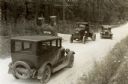
| Date: | 07 1927 |
|---|---|
| Description: | A staged scene showing a car passing a truck while another car is coming the other way. The photograph was taken for International Harvester's Agricultural... |

| Date: | 1924 |
|---|---|
| Description: | Front and back covers of Scenic Wisconsin Motorways, a guide to Wisconsin roads compiled by Victor F. Pettric and published by the Wisconsin Motorists Asso... |
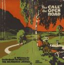
| Date: | 1922 |
|---|---|
| Description: | Front and back cover of the Call of the Open Road, an annual publication of the Milwaukee Journal Tour Department based on its regular columns of mo... |

| Date: | 08 1927 |
|---|---|
| Description: | A man jaywalking across a street in front of a moving automobile. The road is lined with houses and commercial buildings, and additional automobiles are pa... |
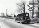
| Date: | 04 23 1926 |
|---|---|
| Description: | A man stops his automobile at a railroad crossing while waiting for the train to cross a paved road. The traffic sign to the right of the car reads: "Railr... |
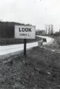
| Date: | 05 1926 |
|---|---|
| Description: | A sign reading: "Look Curve L." is posted along the side of a paved road. An automobile is on the road in the background. |
| Date: | |
|---|---|
| Description: | Letterhead of the Milwaukee Journal Tour Club, a national automobile club, with a three-quarter view of the company building surrounded by scenes of a hote... |
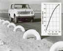
| Date: | 09 28 1966 |
|---|---|
| Description: | Original caption reads: "New, more powerful four cylinder engine for the International Scout proves its worth in an exhibition at a Grand Prix track. Desig... |

| Date: | 1919 |
|---|---|
| Description: | This map shows auto trails, main roads, rivers, and populations of communities. The map also shows selected hotels and garages and includes a key in the ri... |

| Date: | 1917 |
|---|---|
| Description: | This road map shows routes through the state as well as some portions of Iowa, Minnesota, and Michigan. Cities, the Mississippi River, Lake Winnebago, Gree... |

| Date: | 1927 |
|---|---|
| Description: | This map details automobile routes throughout the state as well as parts of Iowa, Minnesota, Michigan and Illinois. Cities, the Mississippi River, Lake Mic... |

| Date: | 1910 |
|---|---|
| Description: | This map shows automobile routes across the state as well as Minnesota, Iowa, Illinois, and Michigan. Cities, Lake Michigan, Lake Superior, the Mississippi... |

| Date: | 1920 |
|---|---|
| Description: | This map details automobile routes spanning across Wisconsin and parts of Illinois, Michigan, Minnesota, and Iowa. Cities, counties, Lake Michigan, Lake Su... |

| Date: | 1894 |
|---|---|
| Description: | This map shows automobile routes across the state and into parts of Illinois, Michigan, Minnesota, and Iowa. Cities, counties, Lake Michigan, Lake Superior... |

| Date: | 1913 |
|---|---|
| Description: | This map details automobile routes throughout the state and parts of Illinois, Minnesota, Michigan, and Iowa. Cities, counties, Lake Michigan, Lake Superio... |

| Date: | 1924 |
|---|---|
| Description: | This map shows automobile routes across the state and into parts of Minnesota, Iowa, Illinois, and Michigan. Cities, Lake Michigan, Lake Superior, Green Ba... |

| Date: | 1919 |
|---|---|
| Description: | This map contains the automobile routes in southern Wisconsin and northern Illinois. Cities, Lake Winnebago and Green Bay are labeled. The orange print on ... |

| Date: | 1915 |
|---|---|
| Description: | This map displays various automobile routes through the state of Wisconsin and parts of Illinois, Iowa, Minnesota, and Michigan. Cities, counties, Lake Mic... |

| Date: | 1913 |
|---|---|
| Description: | This map displays automobile routes across Wisconsin as well as Minnesota, Iowa, Michigan and Illinois. Cities, counties, Lake Michigan, Lake Superior, Gre... |

| Date: | 1920 |
|---|---|
| Description: | The map shows the entire state with cities, rivers, and lakes labeled. The upper and right margin include inset maps of Racine, Milwaukee, Waukesha, Applet... |
If you didn't find the material you searched for, our Library Reference Staff can help.
Call our reference desk at 608-264-6535 or email us at: