 Filter: Subject of automobile driving
Filter: Subject of recreation
Filter: Subject of human settlements
Filter: Subject of automobile driving
Filter: Subject of recreation
Filter: Subject of human settlements
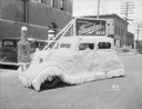
| Date: | 07 27 1934 |
|---|---|
| Description: | An automobile covered in crepe paper with a beer bottle on the front end, and a sign on the top serves as the Fauerbach Brewing Co. float. It was built to ... |
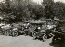
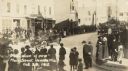
| Date: | 1913 |
|---|---|
| Description: | A slightly elevated view of a parade? of cars driving down a street as onlookers are standing by. |

| Date: | |
|---|---|
| Description: | View down Strong's Avenue, taken from Main Street. An automobile drives past other parked cars and storefronts. |

| Date: | |
|---|---|
| Description: | View down Strong's Avenue, taken from Clark Street. Automobiles park on either side of the street near storefronts. Perpendicular to Strongs Avenue is Main... |
| Date: | |
|---|---|
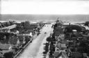
| Description: | Elevated view of Engleside Avenue leading to the ocean. Automobiles drive in the street near dwellings. |

| Date: | 05 02 1958 |
|---|---|
| Description: | Winston Smith and his son, Wade, sit in their restored 1909 Cadillac automobile before the "You Auto Buy Now" parade. |
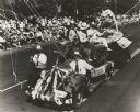
| Date: | 1941 |
|---|---|
| Description: | Slightly elevated view of celebrants at an American Legion convention parade riding on a float made to represent Wisconsin fishing. |

| Date: | 1935 |
|---|---|
| Description: | This colored road map comes with a map legend and explanation, as well as an index of cities and towns (and their populations) in Wisconsin. Information ab... |

| Date: | 1966 |
|---|---|
| Description: | This colored road map shows automobile roads in Wisconsin as well as portions of nearby states. Information on the quality and type of any road shown (inte... |

| Date: | 1970 |
|---|---|
| Description: | This colored map displays detailed maps of Green Bay, Appleton, Racine, Milwaukee, Kenosha, and Duluth-Superior. At the top right is a map location list of... |

| Date: | 1971 |
|---|---|
| Description: | This colored map displays Wisconsin and bordering areas of Iowa, Minnesota, and Michigan. There is color-coding on the map to indicate National Forests, an... |

| Date: | 1973 |
|---|---|
| Description: | This colored map displays Wisconsin and bordering areas of Iowa, Minnesota, and Michigan. There is color-coding on the map to indicate National Forests, a... |

| Date: | 1975 |
|---|---|
| Description: | This colored road map of Wisconsin displays "Featured Points of Interest" and "Historical Points of Interest" in the state, including three color photograp... |

| Date: | 1976 |
|---|---|
| Description: | This colored map displays Wisconsin and portions of bordering states, including a detailed map of the Wisconsin Dells area. Surrounding the map are multipl... |

| Date: | 1977 |
|---|---|
| Description: | This colored map displays Wisconsin and portions of bordering states, including a detailed map of the Wisconsin Dells area. Surrounding the map are multipl... |

| Date: | 1980 |
|---|---|
| Description: | The general theme of this black and white map is "Discover and Enjoy Wisconsin." The front of the map depicts driving tours numbered 1 through 12; each to... |

| Date: | 1952 |
|---|---|
| Description: | This colored map shows the entire state, along with counties in states bordering Wisconsin. There is a key to "Wisconsin Railroads," with initials identify... |
| Date: | 10 20 1915 |
|---|---|
| Description: | Slightly elevated view of the parade for the dedication of the new Main Street. W.A. Holt is driving his automobile, which is decorated with garlands, in t... |
If you didn't find the material you searched for, our Library Reference Staff can help.
Call our reference desk at 608-264-6535 or email us at: