 Filter: Subject of automobile driving
Filter: Subject of rivers
Filter: Subject of roads
Filter: Subject of automobile driving
Filter: Subject of rivers
Filter: Subject of roads
| Date: | |
|---|---|
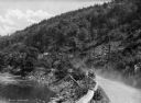
| Description: | A view of a car driving on a dirt road along the Naugatuck River, with a wooden guardrail and river on one side, and a rock formation on the other. |

| Date: | |
|---|---|
| Description: | Elevated view of the Lincoln Highway, also known as the Juniata Bridge, or Juniata Crossing. View toward right side of bridge over a river, with tree-cover... |

| Date: | 1914 |
|---|---|
| Description: | Slightly elevated view of a man driving three women in an International Model M truck on a rural road with a guard rail. In the background is a valley with... |

| Date: | 1914 |
|---|---|
| Description: | Slightly elevated view of a man driving three women in an International Model M truck along a rural road. In the background is a valley with farm buildings... |
| Date: | 1930 |
|---|---|
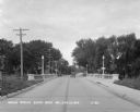
| Description: | View down middle of road of car driving across a bridge over Sugar River. Another car is parked by the Wisconsin Power and Light Company. |
| Date: | |
|---|---|
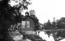
| Description: | Elevated view of a riverside road with waterfront buildings. One of the buildings has a belltower. |

| Date: | 1920 |
|---|---|
| Description: | A two-sided map of the state of Wisconsin. The front includes towns and major cities as well as state and county trunk highways. The back includes a smalle... |

| Date: | 1923 |
|---|---|
| Description: | This map shows trails, some in red, for automobiles. The right margin includes a key of markings as well as Minnesota and Wisconsin Highway signs. Communit... |

| Date: | 1910 |
|---|---|
| Description: | This is a 5 part map showing automobile roads, common roads, cross roads, and railroads. Each map includes a diagram on reverse side and automobile trips o... |

| Date: | 1978 |
|---|---|
| Description: | View from shoreline of Scout II being driven across a river. Trees, hills and a mountain are in the background. The red Scout II has a roof rack and white ... |

| Date: | 1978 |
|---|---|
| Description: | View from shoreline of Scout II being driven across a river. Trees, hills and a mountain are in the background. The red Scout II has a roof rack and white ... |

| Date: | 1948 |
|---|---|
| Description: | This blue line print map shows highways, the scale of traffic volume, and average 24 hour traffic. Also included are inset maps of Appleton, Neenah, and Me... |

| Date: | 1919 |
|---|---|
| Description: | This map shows auto trails, main roads, rivers, and populations of communities. The map also shows selected hotels and garages and includes a key in the ri... |

| Date: | 1917 |
|---|---|
| Description: | This road map shows routes through the state as well as some portions of Iowa, Minnesota, and Michigan. Cities, the Mississippi River, Lake Winnebago, Gree... |

| Date: | 1920 |
|---|---|
| Description: | The map shows the entire state with cities, rivers, and lakes labeled. The upper and right margin include inset maps of Racine, Milwaukee, Waukesha, Applet... |

| Date: | 1930 |
|---|---|
| Description: | This map shows the entire state plus portions of Illinois, Iowa, Minnesota, and Michigan outlined in blue. The map shows roads, state parks (black triangle... |

| Date: | 1933 |
|---|---|
| Description: | This road map shows automobile routes across Wisconsin as well as portions of Illinois, Minnesota, Iowa and Michigan. Lakes Michigan, Superior and Winnebag... |

| Date: | 1934 |
|---|---|
| Description: | This road map contains automobile routes for the state of Wisconsin as well as portions of Minnesota, Illinois, Iowa and Michigan. Lake Michigan, Lake Sup... |

| Date: | 1935 |
|---|---|
| Description: | This road map shows automobile routes across the state of Wisconsin. Advertisements for various hotels are featured along the bottom edge of the map, while... |
If you didn't find the material you searched for, our Library Reference Staff can help.
Call our reference desk at 608-264-6535 or email us at: