 Filter: Subject of automobile driving
Filter: Subject of rivers
Filter: Subject of automobile driving
Filter: Subject of rivers

| Date: | 1978 |
|---|---|
| Description: | View from shoreline of Scout II being driven across a river. Trees, hills and a mountain are in the background. The red Scout II has a roof rack and white ... |

| Date: | 1948 |
|---|---|
| Description: | This blue line print map shows highways, the scale of traffic volume, and average 24 hour traffic. Also included are inset maps of Appleton, Neenah, and Me... |

| Date: | 1919 |
|---|---|
| Description: | This map shows auto trails, main roads, rivers, and populations of communities. The map also shows selected hotels and garages and includes a key in the ri... |

| Date: | 1917 |
|---|---|
| Description: | This road map shows routes through the state as well as some portions of Iowa, Minnesota, and Michigan. Cities, the Mississippi River, Lake Winnebago, Gree... |

| Date: | 1920 |
|---|---|
| Description: | This map shows the entire state as well as portions of Iowa, Illinois, Minnesota, and Michigan. Counties outlined in yellow, cities, rivers, lakes, and rai... |

| Date: | 1920 |
|---|---|
| Description: | The map shows the entire state with cities, rivers, and lakes labeled. The upper and right margin include inset maps of Racine, Milwaukee, Waukesha, Applet... |

| Date: | 1930 |
|---|---|
| Description: | This map shows the entire state plus portions of Illinois, Iowa, Minnesota, and Michigan outlined in blue. The map shows roads, state parks (black triangle... |

| Date: | 1933 |
|---|---|
| Description: | This road map shows automobile routes across Wisconsin as well as portions of Illinois, Minnesota, Iowa and Michigan. Lakes Michigan, Superior and Winnebag... |

| Date: | 1934 |
|---|---|
| Description: | This road map contains automobile routes for the state of Wisconsin as well as portions of Minnesota, Illinois, Iowa and Michigan. Lake Michigan, Lake Sup... |

| Date: | 1935 |
|---|---|
| Description: | This road map shows automobile routes across the state of Wisconsin. Advertisements for various hotels are featured along the bottom edge of the map, while... |

| Date: | 1952 |
|---|---|
| Description: | This colored map shows the entire state, along with counties in states bordering Wisconsin. There is a key to "Wisconsin Railroads," with initials identify... |

| Date: | 1952 |
|---|---|
| Description: | This colored map shows the entire state, along with counties in states bordering Wisconsin. There is a key to "Wisconsin Railroads," with initials identify... |
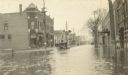
| Date: | 04 13 1922 |
|---|---|
| Description: | The car is plowing through flood waters on Main Street. Commercial buildings and telephone poles are in the background. |
If you didn't find the material you searched for, our Library Reference Staff can help.
Call our reference desk at 608-264-6535 or email us at: