 Filter: Subject of barracks
Filter: Year of 1800-1899
Filter: Subject of barracks
Filter: Year of 1800-1899
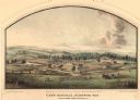
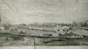
| Date: | 05 1864 |
|---|---|
| Description: | Lithograph of Camp Randall, where the majority of Wisconsin's soldiers were trained and mustered into the Union Army. This view, which was taken from Basc... |
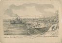
| Date: | 05 1862 |
|---|---|
| Description: | "Hamburg Landing, 4 miles below Pittsburg Landing, Commisary [sic] Depot of Gen. Hallek's Army." An encampment with soldiers along the river with a ... |
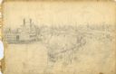
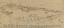
| Date: | 1862 |
|---|---|
| Description: | This is the preliminary sketch for "Hamburg Landing, 4 miles below Pittsburg Landing, Commisary [sic] Depot of Gen. Hallek's Army." Shows an encampm... |
| Date: | 1862 |
|---|---|
| Description: | Fort Lincoln, Kansas, when the 12th Wisconsin Volunteers arrived on their march from Fort Scott to Lawrence. A watercolor by John Gaddis of Company E. |
| Date: | 1862 |
|---|---|
| Description: | Photograph of a watercolor of a view of Camp Randall, from the northeast. Scene set on rolling hills, shows tents, buildings, horses and military members i... |
| Date: | 05 20 1864 |
|---|---|
| Description: | A sketch of Camp Randall made from the top of University Building, May 20, 1864, by W.F. Brown of the 40th Wisconsin Volunteer Infantry Company B. A small... |

| Date: | 1864 |
|---|---|
| Description: | Fort Crawford was decommissioned in 1856, having outlived its usefulness as a frontier post. During the Civil War, however, it functioned as a military ho... |
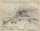
| Date: | 08 08 1862 |
|---|---|
| Description: | Contemporary drawing of the interior of a prison barracks. Quarters of I.D. Cruttenden, Captain and Assistant Quarter Master of the "W.I.V." (Likely signif... |
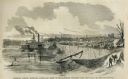
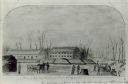
| Date: | 05 31 1862 |
|---|---|
| Description: | Engraved view of the Commisary [sic] depot of Major-General Halleck's army at Hamburg Landing. |

| Date: | 1816 |
|---|---|
| Description: | This is a photostat copy of a manuscript map in the National Archives showing a plan of Fort Howard and a view of its north side. Originally surveyed by Wi... |

| Date: | 1837 |
|---|---|
| Description: | This map shows planned military posts/depots, barracks, rivers, lakes, roads, existing forts, and land assigned to various Indian tribes. Arkansas, Illinoi... |
If you didn't find the material you searched for, our Library Reference Staff can help.
Call our reference desk at 608-264-6535 or email us at: