 Filter: Subject of botany
Filter: Subject of southern states
Filter: Subject of botany
Filter: Subject of southern states
| Date: | |
|---|---|
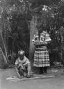
| Description: | A view of two Seminole Native Americans, one person standing and another person crouching near the ground working on something unidentified. |
| Date: | |
|---|---|
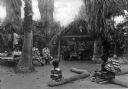
| Description: | A view of Seminole Native Americans seated around camp. The camp consists of a roofed hut, tables, and logs for the Native Americans to sit on. |
| Date: | |
|---|---|
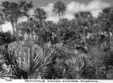
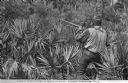
| Description: | A view toward a Seminole Native American hunter pointing a gun while standing in a swamp area with large plants. Trees are in the background. Caption reads... |
| Date: | |
|---|---|
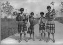
| Description: | A group of four Seminole Native American youth standing on a path with trees behind them. Three of them are holding rifles and one is holding a dead bird. |
| Date: | 1904 |
|---|---|
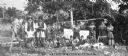
| Description: | A large Seminole Native American family posed outdoors as a group, including men, women and children who are all wearing Seminole native clothing. There ar... |
| Date: | |
|---|---|
| Description: | View of a Seminole Native American, John Doctor, holding a gun and standing in an area dense with plants. Caption reads: "John Doctor -- A Seminole, Fort P... |

| Date: | 1673 |
|---|---|
| Description: | Decorative map of the southeastern region of North America, from the York River in Virginia to northern Florida. The coat of arms of France and England mar... |

| Date: | 1784 |
|---|---|
| Description: | Map of the southeastern region of America to just west of the Mississippi River. It shows borders, cities, towns, forts, Native American land, portages, mo... |

| Date: | 1667 |
|---|---|
| Description: | Map of Virginia depicting the discoveries detailed by John Smith in his exploration of the region. It shows Jamestown, Native American tribes and villages,... |

| Date: | 1671 |
|---|---|
| Description: | Map of Virginia depicting the discoveries detailed by John Smith in his exploration of the region. It shows Jamestown, Native American tribes and villages,... |

| Date: | 1676 |
|---|---|
| Description: | Map of Virginia and Maryland, based on John Smith's 1612 map and Augustine Herman's 1673 seminal map. It shows borders, counties, Native American land, tri... |

| Date: | 1779 |
|---|---|
| Description: | Map of South Carolina showing boundary lines, Native American land, precincts, townships, cities, towns, forts, roads, mountains, hills, swamps, islands, a... |

| Date: | 1760 |
|---|---|
| Description: | Map showing the towns, mountains, valleys, corn fields, and rivers of a portion of the Cherokee Nation. A few annotations on the map explain the land and r... |

| Date: | 1779 |
|---|---|
| Description: | Map of colonial Georgia showing cities, towns, Native American land and towns, forts, roads, trading paths, islands, mountains, swamps, and rivers. Annotat... |

| Date: | 1925 |
|---|---|
| Description: | An original lithograph of a woman buying a necklace from a Native American man. Horseback riders are in the distance. Text at bottom reads: "Land of Histor... |
If you didn't find the material you searched for, our Library Reference Staff can help.
Call our reference desk at 608-264-6535 or email us at: