 Filter: Subject of camps
Filter: Subject of cities and towns
Filter: Subject of camps
Filter: Subject of cities and towns
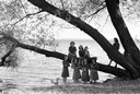
| Date: | 10 10 1941 |
|---|---|
| Description: | Eight Girl Scouts are standing on and near a tree at the edge of Lake Mendota, with the Madison skyline in the background at Camp Indianola. |
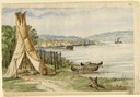
| Date: | 1860 |
|---|---|
| Description: | In April of 1860 Hölzlhuber took the railway from Milwaukee to Lake Horicon to visit the small town that was developing on its shore. Since the settlers we... |

| Date: | 1914 |
|---|---|
| Description: | The Young Men's Christian Association Camp. A man is sitting on the lawn near a small bridge on the left. In the background along the right are buildings. ... |
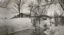
| Date: | 1920 |
|---|---|
| Description: | C.R. Pickering Camp on Mill Creek, in winter with snow on the ground. On the opposite shoreline is a shelter on the hill overlooking the creek, with a set ... |

| Date: | 1925 |
|---|---|
| Description: | A view of the 7-acre Hallelujah Campground which was located at the corner of Janesville Street and South Perry Parkway in the Village of Oregon. According... |

| Date: | 06 28 1949 |
|---|---|
| Description: | Two girls at Brownie Day Camp at Burrows Park. Standing near a boat on the shore of Lake Mendota is Shelia Sullivan, left, daughter of Mr. and Mrs. J.J. Su... |

| Date: | 06 28 1949 |
|---|---|
| Description: | Four girls wading in Lake Mendota. They were attending the Brownie Day Camp at Burrows Park. Left to right: Marilyn Dvorak, daughter of Mr. and Mrs. Alfred... |
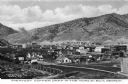
| Date: | |
|---|---|
| Description: | Elevated view of a copper mining camp with desert hills in the background. Caption reads: "Greatest Copper Camp in the World, Ely, Nevada." |

| Date: | 1927 |
|---|---|
| Description: | Blueprint-style map of Frost Woods on the shore of Lake Monona. The map indicates the locations of Indian mounds, an Indian camp, and various plants. There... |
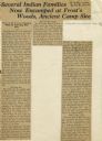
| Date: | 07 05 1928 |
|---|---|
| Description: | Article entitled "Several Indian Families Now Encamped at Frost's Woods, Ancient Camp Site" about Winnebago (Ho-Chunk) Indians camping on the shores of Lak... |

| Date: | 1925 |
|---|---|
| Description: | This map shows state trunk highways, county trunk highways, railroads, canoe trails, lakes, and free public camp sites. The map on the reverse also shows a... |
| Date: | 1966 |
|---|---|
| Description: | Buildings along an unpaved road served as a camp for migrant farm workers working for the Green Bay Food Company. In 1946, more than 4,000 farmworkers fr... |

| Date: | 1926 |
|---|---|
| Description: | This Wisconsin Conservation Commission map from the 1920s shows roads, railroads, campsites, lookout towers, and privately owned lands in Northern Forest S... |

| Date: | 1902 |
|---|---|
| Description: | This 1902 map of the eastern portion of Sawyer County, Wisconsin, shows the township and range system, sections, roads, farm houses, camps, school houses, ... |

| Date: | 1926 |
|---|---|
| Description: | This 1926 map depicts resorts and camps, lakes and streams, railroads, and roads in portions of Vilas, Iron, Oneida, Price, and Lincoln counties in Wiscons... |

| Date: | 1967 |
|---|---|
| Description: | This tourist brochure for Bayfield County, Wisconsin, from 1967 includes a map of the county showing towns, cities and villages, highways and roads, railro... |

| Date: | 1900 |
|---|---|
| Description: | Shows lands belonging to Wisconsin Timber and Land Co., towns, post offices, saw mills, creameries, camps, churches, schools, farm houses, town halls, rail... |

| Date: | 1953 |
|---|---|
| Description: | This mid 20th century map of Vilas County and northeastern Oneida County, Wisconsin, shows the township and range grid, sections, cities and villages, rail... |

| Date: | 1890 |
|---|---|
| Description: | Shows vacant state land, government land, townships, and selected farms, camps, saw mills, etc. in Vilas and Oneida Counties, and part of Iron County. "For... |

| Date: | 1939 |
|---|---|
| Description: | This brochure was intended for tourists and shows resorts, lakes and railroads in northwestern Wisconsin and part of Michigan’s upper peninsula. Also inclu... |
If you didn't find the material you searched for, our Library Reference Staff can help.
Call our reference desk at 608-264-6535 or email us at: