 Filter: Subject of capitol buildings
Filter: Subject of transportation
Filter: Subject of lakes
Filter: Subject of capitol buildings
Filter: Subject of transportation
Filter: Subject of lakes

| Date: | 1908 |
|---|---|
| Description: | Colored map showing a panoramic view of Madison in great detail. The Wisconsin State Capitol is located at the center, with Lake Mendota in the background ... |

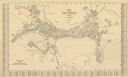
| Date: | 05 09 1908 |
|---|---|
| Description: | Kite aerial panoramic photograph of the central business district. In the distance is Lake Mendota. The fire damaged Wisconsin State Capitol is in the cent... |

| Date: | 1861 |
|---|---|
| Description: | View of Madison from Main Hall, now Bascom Hall, on the University of Wisconsin-Madison campus looking up State Street toward the second Wisconsin State Ca... |

| Date: | 1885 |
|---|---|
| Description: | Bird's-eye map of Madison, State Capital of Wisconsin, County Seat of Dane County, with inset of the Wisconsin State Capitol. |

| Date: | 1875 |
|---|---|
| Description: | View of the Capitol Square from the roof of the Wisconsin State Capitol, looking south. The view includes the Park Hotel, The Baptist Church and St. Raphae... |

| Date: | 1955 |
|---|---|
| Description: | An air view of Madison's downtown area with the Wisconsin State Capitol and new State Office Buildings. |

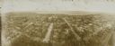
| Date: | 1930 |
|---|---|
| Description: | Aerial view of isthmus looking east toward Lake Mendota and the Wisconsin State Capitol, with Lake Monona and the horizon in the background. |
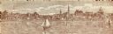
| Date: | 1900 |
|---|---|
| Description: | A view of the city of Madison circa 1900 that was used as a letterhead. |

| Date: | 1904 |
|---|---|
| Description: | View from railroad bed along Monona Bay shoreline. The Wisconsin State Capitol dome is under construction. St. Raphael's Cathedral can be seen on the left. |

| Date: | |
|---|---|
| Description: | Wisconsin Governor Tommy G. Thompson waves from a Harley Davidson motorcycle as he rides on John Nolen Drive. Lake Monona and the Wisconsin State Capitol b... |
| Date: | 1930 |
|---|---|
| Description: | This map is indexed with the north oriented toward the upper right. The map includes a collection manuscript annotations. |

| Date: | 1896 |
|---|---|
| Description: | Shows pipes of various sizes, hydrants with hydrant pressure, valves, wells, projected lines, and suction pipes. Differs from earlier versions by inclusion... |

| Date: | 1929 |
|---|---|
| Description: | This is a blue line print map that shows local streets, railroads, local businesses, schools, parks, cemeteries, the airport, the state capitol, the Univer... |
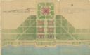
| Date: | 07 1939 |
|---|---|
| Description: | An architectural rendering of a proposed lakefront development plan. |

| Date: | 1970 |
|---|---|
| Description: | This photocopy map shows the locations of historic buildings, as well as all other buildings in the isthmus. The map also includes photographs of selected ... |
| Date: | 1908 |
|---|---|
| Description: | Kite aerial panoramic photograph of the central business district. In the distance is Lake Mendota. The fire damaged Wisconsin State Capitol is in the cent... |
| Date: | 1960 |
|---|---|
| Description: | Elevated view of the Capitol's West Washington entrance. Lake Monona is on the right, and Lake Mendota is on the left. |

| Date: | 1937 |
|---|---|
| Description: | Elevated view of skyline looking down East Washington Avenue. Lake Monona is in the distance on the right. |
If you didn't find the material you searched for, our Library Reference Staff can help.
Call our reference desk at 608-264-6535 or email us at:
