 Filter: Subject of dams
Filter: Subject of education
Filter: Subject of dams
Filter: Subject of education

| Date: | 1872 |
|---|---|
| Description: | Birds-eye drawing of Eau Claire depicts street names and street locations, houses, trees, bridges, piers, canals, railroads, and the Chippewa and Eau Clair... |

| Date: | 1931 |
|---|---|
| Description: | Aerial view looking north, with a small portion of the West Side (left), nearly all of the North Side and part of the business district of the East Side. A... |

| Date: | 1880 |
|---|---|
| Description: | A hand-colored map of the Chippewa, Price, Taylor and the northern part of Clark counties, which shows the locations of farmhouses, schoolhouses, churches,... |

| Date: | 1897 |
|---|---|
| Description: | This 1897 map of Sawyer County, Wisconsin, shows the township and range system, sections, roads, farm houses, camps, school houses, dams, bridges, Indian r... |

| Date: | 1898 |
|---|---|
| Description: | This 1898 map of Sawyer County, Wisconsin, shows the township and range system, sections, roads, farm houses, camps, school houses, dams, bridges, Indian r... |

| Date: | 1902 |
|---|---|
| Description: | This 1902 map of the eastern portion of Sawyer County, Wisconsin, shows the township and range system, sections, roads, farm houses, camps, school houses, ... |

| Date: | 1909 |
|---|---|
| Description: | This 1909 map of Taylor County, Wisconsin, shows the township and range grid, towns, sections, cities and villages, settlers houses, schools, churches, saw... |

| Date: | |
|---|---|
| Description: | This map of Taylor County, Wisconsin, shows soil types, the township and range grid, sections, settlers houses, schools, churches, saw mills, tanneries, ro... |

| Date: | 1873 |
|---|---|
| Description: | This 1873 map of Chippewa County, Wisconsin, which at the time also encompassed all or part of Price, Rusk, Sawyer, and Taylor counties, shows the township... |

| Date: | 1889 |
|---|---|
| Description: | Shows city limits, railroads, mills, schools, cemeteries, dams, parks, lumber yards, log canals, log reservoir, Chippewa River, Eau Claire River, and Half ... |
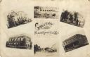
| Date: | |
|---|---|
| Description: | Photographic collage of six views of Black River Falls, featuring the Grade School, High School, Bank, Main Street, a commercial business block and the da... |

| Date: | 07 18 1955 |
|---|---|
| Description: | Five teen boys stand ankle deep in Black Earth Creek (west of Cross Plains) while working together to build a conversion dam in the creek bed. The boys are... |

| Date: | 07 18 1955 |
|---|---|
| Description: | Two teen boys and an adult stand in ankle deep Black Earth Creek (west of Cross Plains) while working together to build a "V" shaped conversion dam, pointi... |
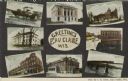
| Date: | 1910 |
|---|---|
| Description: | Color enhanced postcard with eight views of buildings, bridges, and dams. In the center is written: "Greetings from Eau Claire Wis." |

| Date: | 1861 |
|---|---|
| Description: | This map shows townships and sections, landownership, roads, railroads, rural residences, schools, churches, and topography. Also included are inset maps o... |

| Date: | 06 12 1929 |
|---|---|
| Description: | This manuscript blueprint shows buildings with the names of their owners, tabernacle, location "where Strang found plates" and "house where Strang died," a... |
If you didn't find the material you searched for, our Library Reference Staff can help.
Call our reference desk at 608-264-6535 or email us at: