 Filter: Subject of express highways
Filter: Subject of land use, rural
Filter: Subject of express highways
Filter: Subject of land use, rural

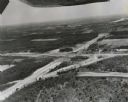
| Date: | 1954 |
|---|---|
| Description: | Elevated view of a newly opened divided four lane highway. |

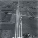
| Date: | 1998 |
|---|---|
| Description: | North-facing aerial view of the interchange between Interstates 39/90 and US Routes 12/18 in the southeast of Madison. Femrite Drive can be seen passing be... |
| Date: | 1960 |
|---|---|
| Description: | Aerial view of the intersection of the interstate highway with USH 12 between Baraboo and Lake Delton with the initial grading largely completed. |

| Date: | 1960 |
|---|---|
| Description: | Aerial view of the construction of the interstate highway near Mirror Lake, showing only the early stages of the bridge construction. |
| Date: | 1979 |
|---|---|
| Description: | Interstate highways I-94 and I-43 running concurrently in Kenosha County. |

| Date: | 1930 |
|---|---|
| Description: | Elevated view of two men driving an International truck on U.S. Highway 75 between Breckenridge and Moorehead in Minnesota. |

| Date: | 09 26 1949 |
|---|---|
| Description: | A car drives down the western portion of the newly opened Madison belt line. The view is looking northwest in the region of Gilbert road (also Whitney Way)... |
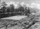
| Date: | |
|---|---|
| Description: | A view on men resurfacing rural sections of U.S. Highway, with machinery and a small train running alongside the road. |
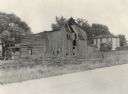
| Date: | 04 06 1926 |
|---|---|
| Description: | View across road of a deteriorating barn and a few sheds. In the background is a young child standing in the yard of a farmhouse. Original caption reads, "... |

| Date: | 03 1984 |
|---|---|
| Description: | "Traveling west over the Theresa Marsh, Hwy 28 intersects Hwy 175 at this intersection." |

| Date: | 1961 |
|---|---|
| Description: | Evacuation route out of Milwaukee. View from the side of the road looking downhill towards the rear of a Wisconsin State Patrol cruiser parked on the right... |

| Date: | 1930 |
|---|---|
| Description: | This map shows communities, state roads, county roads, railroads, lakes and rivers in the county. Areas marked in red are lands tax deeded to the county. |

| Date: | 08 1980 |
|---|---|
| Description: | Two men holding a banner that reads: "Re-think I-43" in protest of the newly built highway. The highway runs from Green Bay to Beloit by way of Milwaukee. |
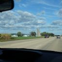
| Date: | 09 21 2014 |
|---|---|
| Description: | View through the windshield of a car towards several light blue farm buildings on the left side of a highway, along with three silo's. The edge of a field ... |
If you didn't find the material you searched for, our Library Reference Staff can help.
Call our reference desk at 608-264-6535 or email us at:
