Filter: Subject of express highways
Filter: Year of 1900-1999
Filter: Subject of express highways
Filter: Year of 1900-1999

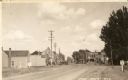
| Date: | 1954 |
|---|---|
| Description: | Elevated view of a newly opened divided four lane highway. |

| Date: | 1930 |
|---|---|
| Description: | View of bridge and Brule River monument. Placed where the Brule River is crossed by the Memorial Highway from Superior to Brule and Ashland (Highway 2). |

| Date: | 1998 |
|---|---|
| Description: | North-facing aerial view of the interchange between Interstates 39/90 and US Routes 12/18 in the southeast of Madison. Femrite Drive can be seen passing be... |

| Date: | 1979 |
|---|---|
| Description: | Aerial view of Interstate I-90/94 at Camp Douglas, looking northwest. |
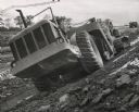
| Date: | 10 1959 |
|---|---|
| Description: | Construction of Interstate Highway I-94 in Waukesha County using an earthmover manufactured by Allis Chalmers. |

| Date: | 1913 |
|---|---|
| Description: | Wisconsin map showing fifteen hundred miles of national highways proposed by the National Highways Association. Scale: 1:2,500,000. These highways will dir... |

| Date: | 1969 |
|---|---|
| Description: | A man is driving a construction truck in the shadow cast by what appears to be an elevated highway. A sign for the "Brooklyn Battery Tunnel" is on one of t... |
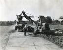
| Date: | 11 11 1937 |
|---|---|
| Description: | A man shovels dirt from a highway five miles north of Richmond next to an Austin-Western Badger shovel powered by a McCormick-Deering engine. The equipmen... |

| Date: | 1962 |
|---|---|
| Description: | Cover of a brochure advertising International Fleetstar BBC Series 1900 and 2000 semi-trucks. The cover features the IHC logo and an illustration of a man ... |

| Date: | 1961 |
|---|---|
| Description: | Three-quarter front view of an International model DCO-405 truck owned by A.C.E. Freight Incorporated as it drives along a highway. |

| Date: | 1961 |
|---|---|
| Description: | An International DF 405 truck owned by Lucky Lager drives down a highway away. The Lucky Lager factory is in the background. |

| Date: | 1923 |
|---|---|
| Description: | This map shows trails, some in red, for automobiles. The right margin includes a key of markings as well as Minnesota and Wisconsin Highway signs. Communit... |

| Date: | 1936 |
|---|---|
| Description: | This 1936 Wisconsin Conservation Dept. map shows the locations of state forestry Civilian Conservation Corps (CCC) camps, closed state forestry CCC camps, ... |
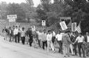
| Date: | 1966 |
|---|---|
| Description: | Marchers of Obreros Unidos (United Workers) leaving Wautoma and walking towards Madison along Highway 21 to petition lawmakers to hold farms and food indus... |

| Date: | 1922 |
|---|---|
| Description: | A road map of Milwaukee County, Wisconsin that shows the township and range system, towns, communities, completed roads, a proposed system of roads, steam ... |

| Date: | 1976 |
|---|---|
| Description: | A street map of Milwaukee County, Wisconsin that identifies the location of schools, hospitals, parks, beaches, streets, freeways, both planned or under co... |

| Date: | 1912 |
|---|---|
| Description: | A map of Monroe County, Wisconsin showing townships, the towns of Sparta, Tomah, Oakdale, Wilton, Cashton, Glendale, Kendall and Wyeville, as well as the U... |

| Date: | 1925 |
|---|---|
| Description: | This 1925 map of the northern portion of Sawyer County, Wisconsin, shows the township and range system, sections, roads, railroads, and lakes and streams i... |

| Date: | 1926 |
|---|---|
| Description: | This 1926 map of Sawyer County, Wisconsin, the township and range system, towns, sections, cities and villages, railroads, highways and roads, and lakes an... |
If you didn't find the material you searched for, our Library Reference Staff can help.
Call our reference desk at 608-264-6535 or email us at: