 Filter: Subject of factories
Filter: Subject of bridges
Filter: Subject of factories
Filter: Subject of bridges
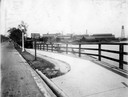
| Date: | 1919 |
|---|---|
| Description: | Deering Works factory seen across the waterfront from Diversey Avenue. In the foreground is a street and sidewalk with the sign "horse vehicles keep to rig... |
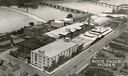
| Date: | 1931 |
|---|---|
| Description: | Aerial view of International Harvester's Rock Falls Works. The factory was owned by the Keystone Manufacturing Company until 1904, when the company was pur... |
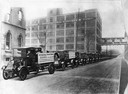
| Date: | 1920 |
|---|---|
| Description: | Long line of International trucks on a road next to International Harvester's Akron Works. Placards on the first two trucks read: "International motor truc... |

| Date: | 1867 |
|---|---|
| Description: | Birds-eye drawing of Appleton, Outagamie Co., depicting street names and street layout, houses, the Fox River, the court house, jail, school houses, Lawren... |

| Date: | 1890 |
|---|---|
| Description: | Bird's-eye map of Beloit with insets of Williams Engine Works, Eclipse Wind Engine Co., and John Foster & Co. Turtle Creek is in the lower section, and the... |

| Date: | 1882 |
|---|---|
| Description: | Bird's-eye views of various sections of Milwaukee. |

| Date: | 1885 |
|---|---|
| Description: | Bird's-eye view of Sheboygan, with inset of J.J. Volrath Manufacturing Company. |

| Date: | 1872 |
|---|---|
| Description: | Birds-eye drawing of Eau Claire depicts street names and street locations, houses, trees, bridges, piers, canals, railroads, and the Chippewa and Eau Clair... |

| Date: | 1891 |
|---|---|
| Description: | Bird's-eye view of Eau Claire. |

| Date: | 1893 |
|---|---|
| Description: | Bird's-eye map of Jefferson, looking north. Crayfish River at left and center, Rock River from upper center to bottom center, joins at left of center; thir... |

| Date: | 12 21 1882 |
|---|---|
| Description: | Bird's-eye map of Kaukauna, from the Appleton Post Annual Review. |

| Date: | 1870 |
|---|---|
| Description: | Bird's-eye view of the city of Manitowoc with a population of 5,168 inhabitants as it appears in 1870, the year the village was granted a city charter by t... |

| Date: | 1874 |
|---|---|
| Description: | Bird's-eye view of Waukesha, looking southwest, with insets of State Industrial School, Court House, and Fountain Spring House. |

| Date: | 1879 |
|---|---|
| Description: | This map is a bird's-eye view of Wausau, the County Seat of Marathon County. The map features an index of points of interest. |

| Date: | 1854 |
|---|---|
| Description: | Bird's-eye view of Milwaukee looking east toward Lake Michigan from a bluff, long since graded into a slope, at about 6th Street between Wisconsin Avenue a... |
| Date: | |
|---|---|
| Description: | Elevated view of the riverfront, railroad tracks, and river, "as viewed from Joseph McGuire's." |
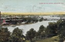
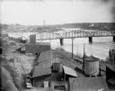
| Date: | 1905 |
|---|---|
| Description: | View from hill looking down towards the Fox River. On the opposite shoreline are industrial buildings. Further down the river on the right are bridges. Cap... |
If you didn't find the material you searched for, our Library Reference Staff can help.
Call our reference desk at 608-264-6535 or email us at:


