 Filter: Subject of factories
Filter: Subject of great lakes
Filter: Subject of factories
Filter: Subject of great lakes

| Date: | 1886 |
|---|---|
| Description: | Bird's-eye view of Bayfield, county seat of Bayfield County. On the lower left side is an inset for Bayfield and the Apostle Islands. |

| Date: | 1913 |
|---|---|
| Description: | Bird's-eye map of Superior. "The New Steel Center." |

| Date: | 1896 |
|---|---|
| Description: | Bird's-eye view of Washburn, with twenty vignettes around side, water in foreground with docks and lumber corral. Thirty-three locations identified in key ... |

| Date: | 1910 |
|---|---|
| Description: | Bird's-eye view looking east, with Washburn Harbor at center and Chequamegon Bay in Lake Superior covering most of the upper image. Streets with buildings... |

| Date: | 1970 |
|---|---|
| Description: | Aerial view of International Harvester's Wisconsin Steel Works, with a river and Lake Michigan in the background. |

| Date: | 1952 |
|---|---|
| Description: | Map of the barley-growing regions of North America, published by the Rahr Malting Company, Manitowoc, Wisconsin, 1952. |

| Date: | 1934 |
|---|---|
| Description: | This map shows industrial points of interest in Superior. The top of the map reads: "Superior, Douglas County, Wisconsin, as this Industrial Tour map indic... |

| Date: | 06 14 1961 |
|---|---|
| Description: | Aerial view of North and South Harbor Tracts, looking north from South Pier No. 2. There are skyscrapers in the background. there are multiple items of mac... |

| Date: | |
|---|---|
| Description: | Aerial view of harbor. In the foreground is a lighthouse and breakwaters. Bridges cross the harbor, and there are factory and industrial buildings near the... |
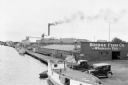
| Date: | 07 1936 |
|---|---|
| Description: | Elevated view of fishing tugs moored alongside the wharf at Marinette. Two automobiles are parked in the foreground, just in front of the Bridge Fish Co. b... |

| Date: | 01 10 1923 |
|---|---|
| Description: | Drawing of aerial view of Harvester Works in Hamilton, Ontario, in Canada. |

| Date: | 01 10 1923 |
|---|---|
| Description: | Drawing of an aerial view of factory in Chatham, Ontario. |

| Date: | 1911 |
|---|---|
| Description: | Map of states in the United States, as well as inset maps of Russia, France, Germany and Sweden. At bottom right is a key for the map that includes: a numb... |
If you didn't find the material you searched for, our Library Reference Staff can help.
Call our reference desk at 608-264-6535 or email us at: