 Filter: Subject of ferries
Filter: Subject of bridges
Filter: Subject of ferries
Filter: Subject of bridges
| Date: | 1940 |
|---|---|
| Description: | Colsac Ferry across the Wisconsin River at Merrimac. There is a bridge across the river in the background on the left. |
| Date: | 1969 |
|---|---|
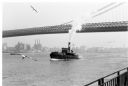
| Description: | The Island's Edge, Williamsburg Bridge, East River. |

| Date: | 1998 |
|---|---|
| Description: | Ile de la Cite, on the Seine River in Paris, France. |
| Date: | 07 13 1915 |
|---|---|
| Description: | Looking south from Wells Street. A boat travels along the Milwaukee River in the foreground. Landmarks left to right: Manufacturers Home Building, First Na... |
| Date: | |
|---|---|
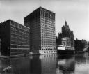
| Description: | Elevated view of two Goodrich Line passenger ferries docked on the west bank of the Milwaukee River, north of the Clybourn Street bridge. The Pabst buildin... |

| Date: | 10 1972 |
|---|---|
| Description: | Gaylord Nelson, Patrick Lucey, and Walter Mondale look over the St. Croix River. In the background a bridge is under construction. |
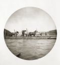
| Date: | 05 06 1894 |
|---|---|
| Description: | View on the Monongahela River of a ferry with passengers and horse-drawn carriages. There is a bridge in the background. |
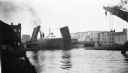
| Date: | 06 1939 |
|---|---|
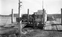
| Description: | Bridge on the Manitowoc River raised to allow the Pere Marquette car ferry through. River dredging equipment can be seen in the foreground. |

| Date: | |
|---|---|
| Description: | A view of the Brownrich ferry carrying a horse and wagon. |

| Date: | 1862 |
|---|---|
| Description: | This detailed map shows batteries and rifle pits, railroads, common and military roads, turnpikes, city streets and names, bridges, ferries, rural houses a... |

| Date: | 1950 |
|---|---|
| Description: | This road map shows federal, state and county roads in Wisconsin, northern Illinois, northeastern Iowa, eastern Minnesota, and the western portion of Michi... |

| Date: | 05 01 1899 |
|---|---|
| Description: | Map showing the Schuylkill River with roads, ferries, and points of interest from Valley Forge to Philadelphia, Pennsylvania as it appeared during the Revo... |

| Date: | 1933 |
|---|---|
| Description: | This map shows the major highways and freeways of Wisconsin as well as road surfaces, state parks, points of interest, ferry routes, bridges, and towns whe... |

| Date: | 11 1781 |
|---|---|
| Description: | Map of New York, Staten Island, and Long Island, showing the placements of forts, and the movement of troops in 1776. The map also includes towns, cities, ... |

| Date: | 06 1971 |
|---|---|
| Description: | The Merrimac Ferry hauling cars across the Wisconsin River. A bridge across the river is in the background behind the ferry. |

| Date: | |
|---|---|
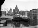
| Description: | View across water towards a Lake Michigan car ferry going through a drawbridge. Caption reads: "Car Ferry Clearing Eighth Street Bridge, Manitowoc, Wis." |
If you didn't find the material you searched for, our Library Reference Staff can help.
Call our reference desk at 608-264-6535 or email us at: