 Filter: Subject of fishes
Filter: Subject of indians of north america
Filter: Subject of fishes
Filter: Subject of indians of north america

| Date: | 1941 |
|---|---|
| Description: | Hand-drawn, watercolor and ink, map of Lake Mendota. Locations and many small figures appear around the shore with explanations referring to Indian legends... |
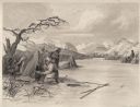
| Date: | 1884 |
|---|---|
| Description: | Small group of Native Americans spearing fish through ice on a river. Mountains can be seen in the background. |

| Date: | 1930 |
|---|---|
| Description: | Original map made with watercolor and inkwash. Includes a legend of buildings, roads, natural features and other details of the lodge. Inset at bottom has ... |

| Date: | 1746 |
|---|---|
| Description: | Map of North America from the southern portion of James Bay to Florida. It shows the colonies, cities, Native American land, and topological and geographic... |
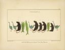
| Date: | 1851 |
|---|---|
| Description: | Kenisteno, and his Band of Trout Lake, Wisconsin. One row of birds, animals and fish pictographs. |
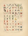
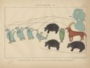
| Date: | 1851 |
|---|---|
| Description: | Synopsis of Indian Hieroglyphics. Pictographs 71-140, including birds, human figures, plants, animals and other symbols. |
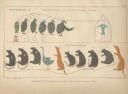
| Date: | 1851 |
|---|---|
| Description: | Two pictographs: Pictograph C., Okundekund, and his Band of Ontonagon, Michigan, and Pictograph D., Kakake-Ogwunaosh, and his Band of the Head of the Wisc... |
| Date: | 1851 |
|---|---|
| Description: | Pictograph E., Plate 63, "Kaizheosh, and his Band from Lake Vieu Desert. Michigan and Wisconsin." A group of symbols including birds, animals, a fish and a... |

| Date: | 1780 |
|---|---|
| Description: | Map of North and South America, showing the boundaries of colonial territories, cities, settlements, rivers, lakes, and Native American land. Particular em... |

| Date: | 1760 |
|---|---|
| Description: | Map of North America based upon the cartographic work of de L'Isle. It shows cities, regions, lakes, rivers, Native American land, mountains, islands, and ... |
If you didn't find the material you searched for, our Library Reference Staff can help.
Call our reference desk at 608-264-6535 or email us at: