 Filter: Subject of fishes
Filter: Subject of maps
Filter: Subject of fishes
Filter: Subject of maps

| Date: | 1966 |
|---|---|
| Description: | A colored map depiction of Door County, Wisconsin, with pictorial highlights, titled: "Door County — Wisconsin's Air Conditioned Peninsula Playground." |

| Date: | 1958 |
|---|---|
| Description: | This map shows state public hunting and/or fishing grounds, national forests, state forests, county forests.The lower margin includes an index to these loc... |

| Date: | 1715 |
|---|---|
| Description: | One of Herman Moll's most famous maps, often referred to as The Codfish Map, it shows rivers and portages, cities, Indian villages, wind directions, routes... |

| Date: | 1746 |
|---|---|
| Description: | Map of North America from the southern portion of James Bay to Florida. It shows the colonies, cities, Native American land, and topological and geographic... |

| Date: | 1780 |
|---|---|
| Description: | Map of North and South America, showing the boundaries of colonial territories, cities, settlements, rivers, lakes, and Native American land. Particular em... |

| Date: | 1760 |
|---|---|
| Description: | Map of North America based upon the cartographic work of de L'Isle. It shows cities, regions, lakes, rivers, Native American land, mountains, islands, and ... |
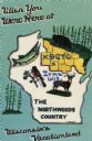
| Date: | |
|---|---|
| Description: | The Northwoods area, numbered K9GTQ, is highlighted yellow inside an outline of the shape of the state of Wisconsin. A muskie, a robin, a bear and a deer a... |

| Date: | |
|---|---|
| Description: | Map showing the location of the Little Bohemia lodge and restaurant, with major routes from Chicago and eastern and central Wisconsin. |
If you didn't find the material you searched for, our Library Reference Staff can help.
Call our reference desk at 608-264-6535 or email us at: