 Filter: Subject of foreign languages
Filter: Subject of rivers
Filter: Subject of foreign languages
Filter: Subject of rivers

| Date: | 1803 |
|---|---|
| Description: | Cours du Mississippi : comprenant la Louisiane, les 2 Florides, une partie des Etats-Unis, et pays adjacents. |
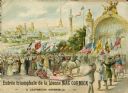
| Date: | 1900 |
|---|---|
| Description: | Color lithograph cover illustration of the French edition of a McCormick catalog, showing a man driving a McCormick reaper through a parade at the 1900 Wor... |

| Date: | 1870 |
|---|---|
| Description: | A geological survey map of Wisconsin, with hand-colored portions showing the surveys completed from 1873 to 1875. Although the title and legend are in Wel... |

| Date: | 1849 |
|---|---|
| Description: | Published in Germany a year after Wisconsin entered statehood, this map shows prairies, swamps, lakes, mounds, limestone deposits, and lead and copper mine... |

| Date: | |
|---|---|
| Description: | Map shows roads, railroads, rivers, and improved farms. Includes text on lands for sale and exchange by B.W. Pulling, successor to Marshfield Land Company.... |

| Date: | 1798 |
|---|---|
| Description: | Engraved and hand-colored map of Egypt. Map title appears on bottom left as a carving in stone next ... |

| Date: | 1608 |
|---|---|
| Description: | Illustraiton, with alphabetical key in French, of the Habitation of Quebec, a conglomeration of connected buildings on the banks of the St. Lawrence River ... |
If you didn't find the material you searched for, our Library Reference Staff can help.
Call our reference desk at 608-264-6535 or email us at: