Filter: Subject of industry
Filter: Subject of fortification
Filter: Subject of industry
Filter: Subject of fortification
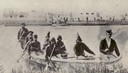
| Date: | 1860 |
|---|---|
| Description: | Nine men arrive at Fort William by canoe. Fort William, also called Kaministiguia, was the Hudson's Bay fur trading post. Men are standing along the opposi... |
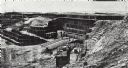
| Date: | 1898 |
|---|---|
| Description: | Ruins of the commissary warehouse at Fort Winnebago, about 1898. Fort Winnebago was closed in 1845 and the land and buildings sold. Today, only the Surgeon... |

| Date: | |
|---|---|
| Description: | View through a window of Indians conversing with traders. Caption reads: "Trade-Room [sic], Hudson Bay Company's Fort, In The Plain Country". |

| Date: | |
|---|---|
| Description: | Several French fur traders negotiating with native Indians at La Baye. |

| Date: | 1847 |
|---|---|
| Description: | A hand-colored map that shows the area south and east of the Wisconsin and Fox Rivers, as well as a few landmarks just north of that area. The township gri... |

| Date: | 1914 |
|---|---|
| Description: | This map is a photostat copy from the original 1829 map in the War Department. The map shows location of Fort Howard, lots, land claims of Jacques Porlier ... |

| Date: | 1867 |
|---|---|
| Description: | This 1867 manuscript map by Increase Lapham shows the topography and geology of the Blue Mounds region in the Town of Brigham in Iowa County and the towns ... |
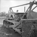
| Date: | 08 22 1943 |
|---|---|
| Description: | Corporal Eugene Cierzynski of Milwaukee, Wisconsin (left) instructs Corporal Edgar Hourscht of Trosky, Minnesota (right), on how to operate a D-8 Caterpill... |
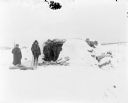
| Date: | 1918 |
|---|---|
| Description: | A group of possibly both American and British soldiers standing just outside a blockhouse fortification. There are piles of logs and an axe on the ground i... |

| Date: | 1918 |
|---|---|
| Description: | A large concrete blockhouse fortification at Verst 581 with a concrete outhouse next to it on the right. An armed solder wearing winter clothing stands be... |
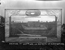
| Date: | 1925 |
|---|---|
| Description: | Painting of Fort Hamilton propped outdoors on a woodpile. An oval inset painting at the top commemorates is titled: "Col. Hamilton Leaving For The Gold Fie... |
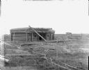
| Date: | 1918 |
|---|---|
| Description: | View of field with a damaged blockhouse constructed of logs, and a smaller outbuilding in the distance. It appears the roof of the fortification has sustai... |
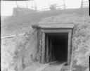
| Date: | |
|---|---|
| Description: | The entrance of an underground bunker built into the side of a hill. The entrance is supported with timber and wooden planks and has wooden flooring. Above... |
| Date: | 1918 |
|---|---|
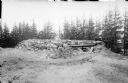
| Description: | A blockhouse fortification built using a timber frame and large stones, with sandbags stacks near the entrance. There appear to be a wires strung along pol... |

| Date: | 1853 |
|---|---|
| Description: | This map shows camps, forts, logging camps, lakes, roads, railroads, the Wisconsin River, and Lac Du Flambeau Indian Reservation. Some points of interest a... |

| Date: | 1900 |
|---|---|
| Description: | This photostat of a manuscript map originally drawn in 1829 shows landownership, buildings, including Fort Howard and U.S. sawmill, swamps, public barns an... |

| Date: | 1900 |
|---|---|
| Description: | This photostat map shows private claim owners, natural meadows, roads, saw and grist mills, and Fort Howard. The upper right corner includes annotations an... |

| Date: | 1862 |
|---|---|
| Description: | This map shows landownership on a military reserve, private claims, buildings (including Fort Howard and U.S. sawmill), swamps, public barns and fields, an... |

| Date: | 1918 |
|---|---|
| Description: | Poster featuring a cartoon illustration of six long lines of men marching into a factory. Poster text reads: "Success in War — depends on co-operation and ... |
If you didn't find the material you searched for, our Library Reference Staff can help.
Call our reference desk at 608-264-6535 or email us at: