 Filter: Subject of industry
Filter: Subject of landforms
Filter: Subject of industry
Filter: Subject of landforms
| Date: | |
|---|---|
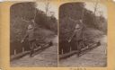
| Description: | Stereograph of a man on a raft throwing a rope. |

| Date: | 1867 |
|---|---|
| Description: | Birds-eye drawing of Appleton, Outagamie Co., depicting street names and street layout, houses, the Fox River, the court house, jail, school houses, Lawren... |

| Date: | 1874 |
|---|---|
| Description: | Bird's-eye map of Chippewa Falls. |

| Date: | 1891 |
|---|---|
| Description: | Bird's-eye view of Eau Claire. |

| Date: | 1880 |
|---|---|
| Description: | Bird's-eye map over the Mississippi River of Fountain City. Paddle steamers and steamboats are on the river, and bluffs are in the background. |

| Date: | 1893 |
|---|---|
| Description: | Bird's-eye map of Jefferson, looking north. Crayfish River at left and center, Rock River from upper center to bottom center, joins at left of center; thir... |

| Date: | 12 21 1882 |
|---|---|
| Description: | Bird's-eye map of Kaukauna, from the Appleton Post Annual Review. |

| Date: | 1910 |
|---|---|
| Description: | Bird's-eye view looking east, with Washburn Harbor at center and Chequamegon Bay in Lake Superior covering most of the upper image. Streets with buildings... |

| Date: | 1900 |
|---|---|
| Description: | Elevated view of the brewery dwarfed by the overhead bluffs. The brewery was built by William Schmitz. George Scheibl ran the brewery from 1899 until his d... |

| Date: | 1829 |
|---|---|
| Description: | Cincinnati, Ohio, Ebr. Martin, engraver. |
| Date: | 1895 |
|---|---|
| Description: | Munger's Mill and dam, with men standing on and around the dam. |
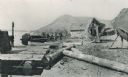
| Date: | 03 1911 |
|---|---|
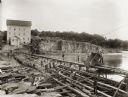
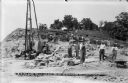
| Description: | Workers use a rail car mounted crane to load pilings onto a barge. Bluffs are in the distance. |
| Date: | 03 1911 |
|---|---|
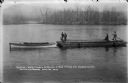
| Description: | A gasoline-powered launch tows a barge loaded with log pilings on the Wisconsin River to the Prairie du Sac dam site. Workmen drive the launch and guide th... |
| Date: | 04 1911 |
|---|---|
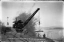
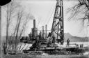
| Description: | Workmen pose on a steam-powered pile driver at work at the north end of the slough on the Wisconsin River. The railroad was extended from the village to th... |
| Date: | 06 19 1911 |
|---|---|
| Description: | Looking west over the Wisconsin River at the unfinished narrow gauge railroad trestle built for construction of the dam. Two pile drivers are seen in the a... |
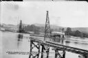
| Date: | 06 21 1911 |
|---|---|
| Description: | Looking east over the Wisconsin River showing the unfinished narrow gauge railroad trestle. Two steam-driven pile drivers on barges with construction worke... |
| Date: | 06 13 1913 |
|---|---|
| Description: | Workmen and machinery at the quarry on Blackhawk Bluff. The gravel was used in construction of the power dam. |
| Date: | 1893 |
|---|---|
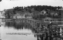
| Description: | Six men of the fishing colony on the shorelines of the Mississippi River. Numerous boats, logs, and fishing nets are scattered across the beach. Caption on... |
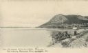
| Date: | 1907 |
|---|---|
| Description: | Fishing implements on the shoreline of the Mississippi River, and a bluff in the background. Caption reads: "Fish Industry, Mississippi River, La Crosse, W... |
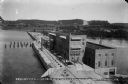
| Date: | 08 19 1915 |
|---|---|
| Description: | Elevated view of the completed power house and dam, looking east at the north, or upstream, side of the structure. On the far shore, the site of the gravel... |
If you didn't find the material you searched for, our Library Reference Staff can help.
Call our reference desk at 608-264-6535 or email us at: