 Filter: Subject of land use, urban
Filter: Subject of cemeteries
Filter: Subject of land use, urban
Filter: Subject of cemeteries

| Date: | 1867 |
|---|---|
| Description: | Drawn map showing planned development of Cornell, including a couple of schools, Oakwood cemetery, the public square, and several bridges and dams. |

| Date: | 1969 |
|---|---|
| Description: | Cemetery with a view across the street of the World Trade Center construction site. |
| Date: | 1969 |
|---|---|
| Description: | View of the construction of the World Trade Center from the churchyard at St. Paul's Chapel. |
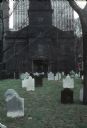
| Date: | 1969 |
|---|---|
| Description: | View of cemetery of St. Paul's Chapel with gravestones. In the background is the construction of the World Trade Center. |

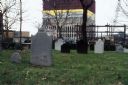
| Date: | 10 11 1954 |
|---|---|
| Description: | Rows of maple trees, turning color, line the 2600 block of Regent Street. The photograph looks east and part of Resurrection cemetery is visible at right. |

| Date: | 09 2001 |
|---|---|
| Description: | Debris from the collapse of the Twin Towers in the churchyard at St. Paul's Church near the World Trader Center, a few days after 9/11. |

| Date: | 1939 |
|---|---|
| Description: | This is a zoning map of Wauwatosa with a key of districts including agricultural, resident, business, commercial, and industrial. The map features labeled ... |

| Date: | 1964 |
|---|---|
| Description: | This map shows various zoning sections and includes labeled streets, parks, and cemeteries. The upper left corner contains a legend of land use. |

| Date: | 11 15 1957 |
|---|---|
| Description: | This map shows single family residence district, business district, and manufacturing district, as well as block and lot numbers, Hustis Homestead, gravel ... |

| Date: | 1965 |
|---|---|
| Description: | This map shows 32 zoning districts, house numbering system, parks, cemeteries, and Milwaukee County institutional buildings. |

| Date: | 1904 |
|---|---|
| Description: | Map showing lots, additions, and wards within the city limits, as well as some landownership. The streets are labeled, as is Lake Winnebago, rivers, railro... |

| Date: | 1900 |
|---|---|
| Description: | This set of maps contains four sheets: "Landownership in the Vicinity of Military Reserve and Fort Howard," "Houses Along the River Road to Green Bay," "Ow... |

| Date: | 1789 |
|---|---|
| Description: | Map of New York City showing ward boundaries, ferries, streets, roads, swamps, ponds, and rivers. The properties of Lispinard, Byards, Jones, Rutgers, and ... |
If you didn't find the material you searched for, our Library Reference Staff can help.
Call our reference desk at 608-264-6535 or email us at: