 Filter: Subject of land use, urban
Filter: Subject of church buildings
Filter: Subject of land use, urban
Filter: Subject of church buildings
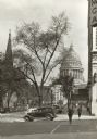
| Date: | 1939 |
|---|---|
| Description: | View down sidewalk along West Washington Avenue, looking toward the Capitol. A man is crossing the street and there is a car at the corner that has the wor... |

| Date: | 1908 |
|---|---|
| Description: | A panoramic aerial view of the Isthmus taken from a kite. Lake Mendota is to the right in the background with Picnic Point jutting into the lake. The photo... |
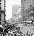
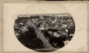
| Date: | |
|---|---|
| Description: | Elevated view of crowd along sidewalks on State Street, and the Masonic Temple from Madison Street. Streetcars and horse-drawn vehicles are in the street. |
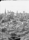
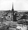
| Date: | |
|---|---|
| Description: | View of buildings from the dome of the Exposition building, including a church and the Best Brewing Company in the distance. |

| Date: | 1965 |
|---|---|
| Description: | Man delivering a stack of Boston Herald newspapers from an International C-series truck parked along the curb in the downtown Boston area at Boston Common.... |

| Date: | 1861 |
|---|---|
| Description: | View of Madison from Main Hall, now Bascom Hall, on the University of Wisconsin-Madison campus looking up State Street toward the second Wisconsin State Ca... |
| Date: | 1861 |
|---|---|
| Description: | View of Madison from Main Hall, now Bascom Hall, on the University of Wisconsin-Madison campus. North Hall is in the foreground with several residences and... |
| Date: | 11 11 1861 |
|---|---|
| Description: | Panoramic view of Madison from Main Hall, now Bascom Hall, on the University of Wisconsin campus. North Hall and South Hall are in the foreground. Lake Men... |

| Date: | 1854 |
|---|---|
| Description: | Bird's-eye view of Milwaukee looking east toward Lake Michigan from a bluff, long since graded into a slope, at about 6th Street between Wisconsin Avenue a... |

| Date: | 1937 |
|---|---|
| Description: | Bird's-eye view of Milwaukee in 1853 details building features and city layout from southwest. Important buildings are numbered in a silhouette drawing bel... |

| Date: | 1892 |
|---|---|
| Description: | Bird's-eye view of Chicago, with ships in the Lake Michigan harbor. |
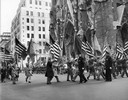
| Date: | 11 08 1953 |
|---|---|
| Description: | Catholic War Veterans of America parade in front of St. Patrick's Cathedral in recognition of Armistice Day. |
| Date: | 1861 |
|---|---|
| Description: | View up State Street looking toward the Wisconsin State Capitol from the roof of University Hall (later Bascom Hall), about 1860 or 1861. Actually the pho... |
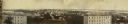
| Date: | 1900 |
|---|---|
| Description: | View from bluff looking northwest at the town of Cassville. A church in the center is the dominant structure in the foreground. Caption reads: "Souvenir - ... |
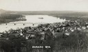
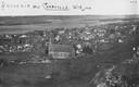
| Date: | 1910 |
|---|---|
| Description: | Elevated view of Durand from a high vantage point, looking towards the river. A bridge spans the river, and in the foreground just below the hill is a chur... |
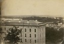
| Date: | |
|---|---|
| Description: | Elevated view of the First Congregational Church and chapel at the corner of North Fairchild Street and West Washington Avenue. The Gates of Heaven Synagog... |

| Date: | 1955 |
|---|---|
| Description: | Elevated view of Capitol Square, looking northwest up Carroll Street at its intersection with Main Street. |

| Date: | 11 1928 |
|---|---|
| Description: | Aerial view of Verona including businesses, houses, and the surrounding farm land. |

| Date: | 10 1928 |
|---|---|
| Description: | Aerial view of Sun Prairie, including the central business district, residences, and the surrounding countryside stretching to the horizon. |
If you didn't find the material you searched for, our Library Reference Staff can help.
Call our reference desk at 608-264-6535 or email us at:
