 Filter: Subject of land use, urban
Filter: Subject of dams
Filter: Subject of land use, urban
Filter: Subject of dams

| Date: | 1930 |
|---|---|
| Description: | Aerial view of the city and the river. |

| Date: | 1867 |
|---|---|
| Description: | Drawn map showing planned development of Cornell, including a couple of schools, Oakwood cemetery, the public square, and several bridges and dams. |
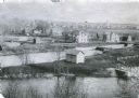
| Date: | 1900 |
|---|---|
| Description: | Elevated view from the south. The Fox River is in the foreground with the dam just visible in the lower right. The lock is seen in the center; the Montello... |

| Date: | 05 11 1902 |
|---|---|
| Description: | Looking up the Milwaukee River to the Humboldt Avenue bridge, with the North Avenue dam in the background. |

| Date: | 1923 |
|---|---|
| Description: | Elevated view of the Milwaukee River from the east bank at the North Avenue dam. Caption on negative reads: "Milwaukee River at North Ave". |

| Date: | 11 15 1957 |
|---|---|
| Description: | This map shows single family residence district, business district, and manufacturing district, as well as block and lot numbers, Hustis Homestead, gravel ... |
If you didn't find the material you searched for, our Library Reference Staff can help.
Call our reference desk at 608-264-6535 or email us at: