 Filter: Subject of mountains
Filter: Subject of birds
Filter: Subject of mountains
Filter: Subject of birds

| Date: | 1832 |
|---|---|
| Description: | Fort Clark, on the Missouri River, February 1834. |

| Date: | 1854 |
|---|---|
| Description: | Drawing of the Porcupine Mountains on Lake Superior. A deer is standing in the lake drinking water. A man is on the rock ledge above the shoreline and is a... |
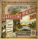
| Date: | 1880 |
|---|---|
| Description: | Cover of a McCormick Harvesting Machine Company fair circular (catalog). The cover is illustrated with a lake and mountain scene and includes the text "Man... |

| Date: | 1696 |
|---|---|
| Description: | Engraved and hand-colored map of Ethiopia, from Blaeu's General Atlas. Map title is framed by a man and a woman, both wearing head turbans, who are standin... |
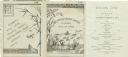
| Date: | 08 09 1879 |
|---|---|
| Description: | Dinner menu from the Steamer Japan of the Lake Superior Transit Company, with a panel including a stalk of bamboo, a dragonfly, and a butterfly, and... |
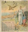
| Date: | 1893 |
|---|---|
| Description: | Calendar front, with the month of January, 1893. At the top it reads: "1893 calendar presented to the farmers of the world with the compliments of Aultman,... |

| Date: | 1685 |
|---|---|
| Description: | A detailed map of the western hemisphere showing cities, settlements, Native American land, rivers, lakes, mountains, the Great Lakes, and California as an... |

| Date: | 1746 |
|---|---|
| Description: | Detailed map of the western hemisphere and part of Africa and Europe. Islands, cities, settlements, rivers, lakes, countries, and regions are marked. Mount... |

| Date: | 1719 |
|---|---|
| Description: | Map of North America showing land divisions between France, Spain, England, Sweden, Denmark and Holland. The map is detailed, labeling cities, forts, islan... |

| Date: | 1720 |
|---|---|
| Description: | Detailed, ornate, and comprehensive map of America from the east coast to present day Texas. Numerous features appear throughout the map, including Native ... |
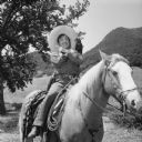
| Date: | |
|---|---|
| Description: | Outdoor publicity still of Pancho, actor Leo Carillo, sitting on horseback. He is posing with his arms crossed in front of his chest, and a bird (stuffed?)... |
If you didn't find the material you searched for, our Library Reference Staff can help.
Call our reference desk at 608-264-6535 or email us at:

