 Filter: Subject of mountains
Filter: Subject of social issues
Filter: Subject of mountains
Filter: Subject of social issues
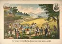
| Date: | 1883 |
|---|---|
| Description: | Advertising lithograph depicting the first public demonstration of a mechanical reaper by Cyrus Hall McCormick at Steeles Tavern, Virginia, in 1831. The sc... |
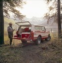
| Date: | 1976 |
|---|---|
| Description: | Color advertising photograph of a fisherman unloading gear from the rear of an International Scout II XL pickup near a mountain lake. |
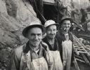
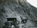
| Date: | 1958 |
|---|---|
| Description: | Construction workers O.R. Williams, Fred Mappin, and Rober Garner at the site of the Mammoth Pool Dam on the San Joaquin River in the Sierra Nevada Mountai... |
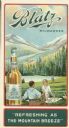
| Date: | |
|---|---|
| Description: | Advertisement for Blatz Private Stock, a "de-alcoholized" beer brewed in Milwaukee during Prohibition. Depicts a couple picnicking near a lake and mountain... |

| Date: | 1965 |
|---|---|
| Description: | Writer and conservationist Wallace Stegner, and his wife Mary, during a visit to Alaska as a member of the National Parks Advisory Board and special assist... |
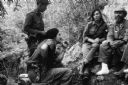
| Date: | 1958 |
|---|---|
| Description: | 26th of July Movement soldiers, including Raúl Castro and Vilma Espin, resting by a rocky cliff-side in Oriente Province during the Cuban Revolution. |
| Date: | 03 1932 |
|---|---|
| Description: | Men use International trucks to loads from the cliffs during the construction of the Hoover Dam. One of the men is smoking a cigarette. Two shovels are wor... |

| Date: | 1783 |
|---|---|
| Description: | This map is hand-colored and shows the boundaries of British, Spanish, and the newly recognized American claims, as well as the fishing rights granted to F... |

| Date: | 1770 |
|---|---|
| Description: | The south west sheet of a four sheet map of Virginia, showing the counties, mountains, rivers, court houses, a few cities, and mills. A few Plantations ar... |

| Date: | 1755 |
|---|---|
| Description: | Map of Virginia and parts of Maryland, North Carolina, and New Jersey. It shows borders, boundary lines, some Native American land, counties, cities, towns... |
| Date: | 1941 |
|---|---|
| Description: | Drawing of a railroad employee standing on a handcar on the tracks painting the surface of a "tunnel" with a brush. Another man is looking at him with a ha... |
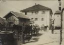
| Date: | |
|---|---|
| Description: | Soldiers relaxing in front of the Folgaria Hotel in Italy. The men are standing around horse-drawn wagons and carts, and other men are walking down a stree... |
| Date: | |
|---|---|
| Description: | Butchers slaughtering beef on the Tirolian battlefront. |

| Date: | |
|---|---|
| Description: | Montenegrin children selling devalued paper money to our soldiers. |
If you didn't find the material you searched for, our Library Reference Staff can help.
Call our reference desk at 608-264-6535 or email us at: