 Filter: Subject of political science
Filter: Subject of beavers
Filter: Subject of political science
Filter: Subject of beavers
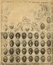
| Date: | 1862 |
|---|---|
| Description: | Composite of photographs of the members of the Wisconsin Senate of 1862. At the top is a depiction of the Wisconsin State Capitol. Banner in center top rea... |
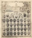
| Date: | 1862 |
|---|---|
| Description: | Composite of photographs of the Wisconsin Senate of 1862. At the top is a depiction of the Wisconsin State Capitol framed by two draped U.S. Flags. Below t... |

| Date: | 1720 |
|---|---|
| Description: | One of Herman Moll's most famous maps, often referred to as The Beaver Map for its elaborate engraved inset depicting and describing beavers building a dam... |

| Date: | 1746 |
|---|---|
| Description: | Map of North America from the southern portion of James Bay to Florida. It shows the colonies, cities, Native American land, and topological and geographic... |

| Date: | 1780 |
|---|---|
| Description: | Map of North and South America, showing the boundaries of colonial territories, cities, settlements, rivers, lakes, and Native American land. Particular em... |

| Date: | 1719 |
|---|---|
| Description: | Map of the Great Lakes and the St. Lawrence river showing French and English cities and villages, trading posts, Indian villages and tribes, portages, for... |
If you didn't find the material you searched for, our Library Reference Staff can help.
Call our reference desk at 608-264-6535 or email us at: