 Filter: Subject of political science
Filter: Subject of coasts
Filter: Subject of political science
Filter: Subject of coasts
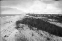
| Date: | |
|---|---|
| Description: | View from beach dunes looking north. View features many plants on sand dunes in the forefront, and people on a sandy beach, many dwellings, and a flag in t... |

| Date: | 1776 |
|---|---|
| Description: | Map showing the English claims in America at the outbreak of the Revolutionary War. Lotter labels each of the thirteen colonies (both in the map and in the... |

| Date: | 1780 |
|---|---|
| Description: | Map of North America east of Mexico showing colonial boundaries, forts, cities, Native American land, mountains, waterfalls, lakes, and rivers. Short notes... |
If you didn't find the material you searched for, our Library Reference Staff can help.
Call our reference desk at 608-264-6535 or email us at: