 Filter: Subject of political science
Filter: Subject of exploration
Filter: Subject of political science
Filter: Subject of exploration

| Date: | 09 1972 |
|---|---|
| Description: | Astronauts Eugene Cernan and Harrison Schmitt practice operating the lunar roving vehicle (LRV) in preparation for the Apollo 17 mission to the moon. They ... |

| Date: | |
|---|---|
| Description: | Astronaut Donald K. Slayton of Sparta, Wisconsin. Slayton enlisted in the Army Air Corps in 1942 at age 18 and flew 56 combat missions in B-25s during Worl... |

| Date: | 1893 |
|---|---|
| Description: | Front and back covers of an advertising brochure for the New Empire line of mowers, reapers and grain binders manufactured by J.F. Seiberling & Company. Th... |

| Date: | 1855 |
|---|---|
| Description: | Map reads "Our Country" which is accompanied by a sailor with a flag to the left and workers rejoicing under the Constitution and Laws to the right. Across... |
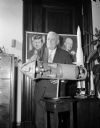
| Date: | 09 14 1962 |
|---|---|
| Description: | Senator Alexander Wiley posing with a cutaway model of an Apollo rocket. Behind him on a wall are portraits of Dwight D. Eisenhower and John F. Kennedy. |

| Date: | 10 23 1962 |
|---|---|
| Description: | Senator Alexander Wiley posing with a model of a missile. Near him on the desk are an American Flag and a globe. |
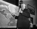
| Date: | 10 24 1962 |
|---|---|
| Description: | Senator Alexander Wiley posing with a model of a missile pointed at a map of Cuba. |

| Date: | 1715 |
|---|---|
| Description: | One of Herman Moll's most famous maps, often referred to as The Codfish Map, it shows rivers and portages, cities, Indian villages, wind directions, routes... |

| Date: | 1720 |
|---|---|
| Description: | This map of North America shows cities, rivers, lakes, and a few topographical features, complete with numerous descriptive blocks of text about expedition... |

| Date: | 1755 |
|---|---|
| Description: | This map shows forts, missions, villages and cities, rivers and portages, and boundaries of the Spanish, English, and French territories, marking the large... |

| Date: | 1783 |
|---|---|
| Description: | This map is hand-colored and shows the boundaries of British, Spanish, and the newly recognized American claims, as well as the fishing rights granted to F... |

| Date: | 1705 |
|---|---|
| Description: | Map of America east of the Mississippi River showing boundaries, rivers, portages, forts, cities, villages, and Native American land. Annotations on early ... |

| Date: | 1710 |
|---|---|
| Description: | Map of North America showing the European claims, Native American land and villages, rivers, lakes, cities, and notes on explorers, discoveries, and topogr... |

| Date: | 1766 |
|---|---|
| Description: | This map of North America shows the boundaries of European claims at the end of the French and Indian war. The British colonies extend to the Mississippi. ... |

| Date: | 1770 |
|---|---|
| Description: | Map of North America showing the boundaries between French, Spanish, and English claims after the French and Indian War. Kitchin includes numerous place na... |

| Date: | 1782 |
|---|---|
| Description: | Map of America covering the Rio Grande to the Atlantic Ocean, showing boundaries, the colonies, cities, settlements, Native American lands and villages, m... |
If you didn't find the material you searched for, our Library Reference Staff can help.
Call our reference desk at 608-264-6535 or email us at: