Filter: Subject of quarries and quarrying
Filter: Subject of rivers
Filter: Subject of quarries and quarrying
Filter: Subject of rivers
| Date: | 06 06 1977 |
|---|---|
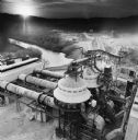
| Description: | Elevated view of a kiln drive that was purchased and used by Dravo Line. Original Falk caption reads, "Color view of May 1977 Pit and Quarry. Photos sent t... |
| Date: | |
|---|---|
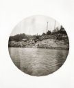
| Description: | View across water toward the marble quarries at the edge of Dorset. They are said to be the oldest in the country and provided the marble for buildings suc... |

| Date: | 1883 |
|---|---|
| Description: | Bird's-eye view of Montello, county seat of Marquette County. The granite quarry, woolen mill, and planing mill are clearly identified. A steamboat on Buf... |
| Date: | |
|---|---|
| Description: | View across river of York Iron Works. On the hill are the boardinghouse and dance hall. Just below the boardinghouse there appears to be a quarry. |

| Date: | 1917 |
|---|---|
| Description: | A geological survey map that shows the sedimentary and igneous deposits in southeastern Wisconsin and south central Wisconsin, as well as the limits of gla... |

| Date: | 1836 |
|---|---|
| Description: | This map is pen-and-ink on paper and shows marshlands, rivers, creeks, a quarry, and a few roads. |

| Date: | |
|---|---|
| Description: | View down railroad tracks towards a group of men posing standing near and on a rock face and a track, with a river on the left. Identified as probably the ... |

| Date: | |
|---|---|
| Description: | View across railroad tracks towards a group of men standing near and on a rock face an a cliff above a river. Identified as probably the quarry connected t... |

| Date: | |
|---|---|
| Description: | Elevated view of a group of men posing standing near and on a rock face with two sets of small railroad tracks behind them. Identified as probably the quar... |

| Date: | 1858 |
|---|---|
| Description: | This map shows city wards, streets, block and lot numbers, cemeteries, buildings, landownership, forests, railroads, a race course, quarries, and orchards.... |

| Date: | 06 12 1929 |
|---|---|
| Description: | This manuscript blueprint shows buildings with the names of their owners, tabernacle, location "where Strang found plates" and "house where Strang died," a... |
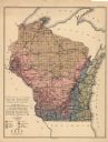
| Date: | 1897 |
|---|---|
| Description: | This map shows the location of quarries throughout the state. Original caption reads, "Geology taken from General Geological Map of Wisconsin by the First ... |
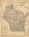
| Date: | 1897 |
|---|---|
| Description: | This map shows the location of quarries throughout the state. Original caption reads, "Geology taken from General Geological Map of Wisconsin by the First ... |

| Date: | 1905 |
|---|---|
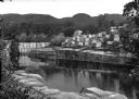
| Description: | A well-dressed man is standing on the bank of the Montello River just below the dam, which was owned and operated by the Montello Granite Company. On the o... |

| Date: | 1905 |
|---|---|
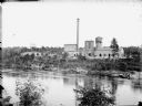
| Description: | A winter view of the dam, left, on the Montello River and ice formations under the shed on the right. The polishing shed of the Montello Granite Company is... |

| Date: | 1864 |
|---|---|
| Description: | This map shows locations of quarries, sink holes, creeks, springs, rivers, houses, forts, and roads. Annotations in pencil read: "Is the top of the mound l... |
If you didn't find the material you searched for, our Library Reference Staff can help.
Call our reference desk at 608-264-6535 or email us at: